|
Misnomers in American English - 4
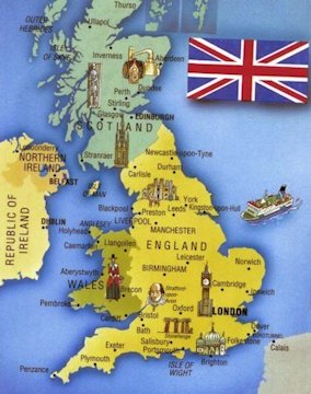
Type of Misnomer : A part used for the whole thing. England is a country that is part of the United Kingdom It shares land borders with Scotland to the north and Wales to the west. The Irish Sea lies north west of England, whilst the Celtic Sea lies to the south west. The North Sea to the east and the English Channel to the south separate it from continental Europe. Most of England comprises the central and southern part of the island of Great Britain which lies in the North Atlantic. The country also includes over 100 smaller islands such as the Isles of Sicily, and the Isle of Wight. England shares legal system and some institutions with its neighbor Wales. The Kingdom of England - which after 1284 included Wales - was a sovereign state until 1 May 1707, when the Acts of Union put into effect the terms agreed in the Treaty of Union the previous year, resulting in a political union with the Kingdom of Scotland to create the Kingdom of Great Britain. In 1801, Great Britain was united with the Kingdom of Ireland through another Act of Union to become the United Kingdom of Great Britain and Ireland. In 1922, the Irish Free State was established as a separate dominion, but the Royal and Parliamentary Titles Act 1927 re-incorporated Northern Ireland to officially create the current United Kingdom of Great Britain and Northern Ireland. Holland is a region and former province located on the western coast of the Netherlands. The term Holland is also frequently used as a pars pro toto to refer to the whole of the country of the Netherlands. This usage is generally accepted, but some individuals, particularly from the other parts of the Netherlands, dislike the use of "Holland" as a substitute for "the Netherlands." |
| Map of Great Britain | |
| ⇦ Back to Misnomer 3 Return to Misnomer Choices On to Misnomer 5 | |