|
China Map of Persons per Square Kilometer
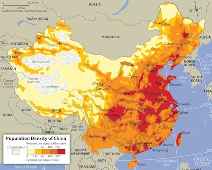
The most densely populated provinces are in the east: Jiangsu (712 persons per square kilometer), Shandong (587 persons per square kilometer), and Henan (546 persons per square kilometer). Shanghai was the most densely populated municipality at 2,646 persons per square kilometer. The least densely populated areas are in the west, with the Tibet Autonomous Region having the lowest density at only 2 persons per square kilometer. Population density (people per sq. km) in China was last measured at 144.10 in 2011, according to the World Bank. Population density is midyear population divided by land area in square kilometers. Population is based on the de facto definition of population, which counts all residents regardless of legal status or citizenship--except for refugees not permanently settled in the country of asylum, who are generally considered part of the population of their country of origin. Land area is a country's total area, excluding area under inland water bodies, national claims to continental shelf, and exclusive economic zones. In most cases the definition of inland water bodies includes major rivers and lakes. Return to Chinese Demographic Population Choices |