|
Yearly Weather for Zhangjiakou, Hebei, China Zhangjiakou City is divided into three topographical regions: plateau, mountains, and basin. The former has elevations generally above 1,400 meters (4,600 ft), and consists of all of Guyuan and Kangbao Counties as well as part of Shangyi and Zhangbei Counties. This area is part of the southern end of the Inner Mongolia Plateau and accounts for one-third of the prefecture's area. The basin area has elevations of 500 to 1,000 meters (1,600 to 3,300 ft) and supports a few rivers. Zhangjiakou has a monsoon-influenced, continental semi-arid climate with long, cold, dry, and windy winters due to the Siberian anticyclone, and hot, humid summers driven by the East Asian monsoon; in between spring and autumn are dry and brief. Conditions are much cooler than in Beijing due in part to the elevation. Winters last from mid-November to late March and at their height in January, temperatures typically remain below freezing all day. In summer, temperatures often reach or surpass 30 ºC (86 ºF). Return to Yearly China Weather Choices - Page 3 |
|
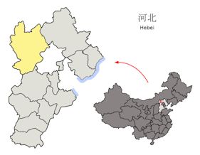
Location of Zhangjiakou in
Hebei Province in China |
|

|
|