|
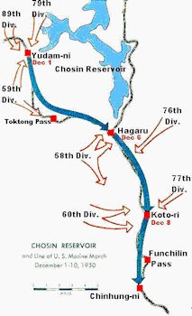
Marines and Chinese Forces in Chosin Reservoir Area
Distances North to South
Yudam-ni to Hagaru-ri ------- 14 Miles -- Hagaru-ri to Koto-ri ---------11 Miles
The 59th, 79th and 89th Divisions had been effectively put out of the fight. However, the 58th, 60th, 76th and the 77th Divisions composed of 40,000 men in the hills commanded the 21 miles between Hagaru and Chinhung-ni. The road begins at Hungnam. From Hungnam to Hamhung is 8 miles; from Hamhung to Sudong 29 miles; from Sudong to Chinhung-ni 6 miles; from Chinhung-ni to Koto-ri 10 miles; from Koto-ri to Hagaru 11 miles, and from Hagaru to Yudam-ni 14 miles. Not a mile was easy. Narrow and winding, oxcarts had a hard time passing, let alone tanks, trucks and artillery. Dirt and gravel constituted most of the road. At times it seemed to go straight up; at other times straight down. It went from low country to towering peaks. The most difficult was Funchilin Pass, a slow, steady climb of eight miles to the high country, 2,500 feet up to Koto-ri. North of Koto-ri the road runs into a high plateau, then continues on to Hagaru, most of which had been flattened by bombing. Above Hagaru, at the southern tip of the Chosin Reservoir, the road climbs and winds up to Toktong Pass, 4,000 feet high, then drops into Yudam-ni Valley. There it splits, one route continuing north, another west. Return to Korean Map Choices |