|
American Samoa
Background:
Settled as early as 1000 B. C., Samoa was "discovered" by European
explorers in the 18th century. An 1899 treaty in which Germany settled
international rivalries in the latter half of the 19th century and the US
divided the Samoan archipelago. The US formally occupied its portion - a
smaller group of eastern islands with the excellent harbor of Pago Pago - the
following year.
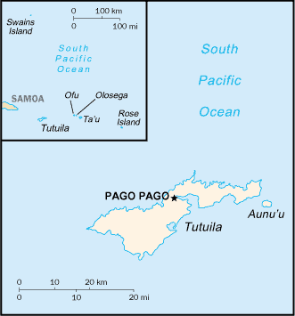
Location:
Oceania, group of islands in the South Pacific Ocean, about one-half of
the way from Hawaii to New Zealand. Area: Total: 199 sq km, note: includes Rose
Island and Swains Island. Area - comparative: Slightly
larger than Washington, DC.
Coastline: 116 km.
Climate and Terrain:
Tropical marine, moderated by southeast trade winds; annual
rainfall
averages about 3 m; rainy season from November to April, dry
season from May to
October; little seasonal temperature
variation.
Five volcanic islands with rugged peaks and limited coastal
plains,
two coral atolls (Rose Island, Swains Island).
Elevation
extremes: Lowest point: Pacific Ocean 0 m, highest point: Lata 966
m.
Natural resources: Pumice, pumicite.
Land use: Arable land: 5%,
permanent crops: 10%, forests and woodland: 70%.
People:
Population: 67,084.
Ethnic groups: Samoan (Polynesian) 89%, Caucasian 2%,
Tongan 4%, other 5%.
Religions: Christian Congregationalist 50%, Roman
Catholic 20%, Protestant and
other 30%.
Languages: Samoan (closely
related to Hawaiian and other Polynesian languages),
English note: most
people are bilingual.
Government:
Dependency status: Unincorporated and unorganized territory of the
US;
administered by the Office of Insular Affairs, US Department of the
Interior.
Capital: Pago Pago.
Economy overview:
This is a traditional Polynesian economy in which more than
90% of the
land is communally owned. Economic activity is strongly linked to
the US,
with which American Samoa conducts the great bulk of its foreign
trade.
Tuna fishing and tuna processing plants are the backbone of the
private sector,
with canned tuna the primary export. Transfers from the
US Government add
substantially to American Samoa's economic well being.
Labor force: 14,000.
Labor force - by occupation: Government 33%,
tuna canneries 34%, other 33%.
Unemployment rate: 16%.
Agriculture - products: Bananas, coconuts, vegetables, taro, breadfruit,
yams,
copra, pineapples, papayas; dairy products, livestock.
Statistics:
Telephones - main lines in use: 13,000.
Telephones - mobile cellular: 2,550.
Radio broadcast stations: AM 1, FM 1.
Radios: 57,000.
Television broadcast stations: 1.
Televisions: 14,000.
Highways: Paved: 150 km, unpaved: 200 km.
Airports: with paved
runways: 2, with unpaved runways: 2.
Return to Visiting Locations
|