|
Belgium
Background:
Belgium became independent from the Netherlands in 1830 and was occupied by
Germany during World Wars I and II. It has prospered in the past half century
as a modern, technologically advanced European state and member of NATO and the
EU. Tensions between the Dutch-speaking Flemings of the north and the
French-speaking Walloons of the south have led in recent years to
constitutional amendments granting these regions formal recognition and
autonomy.
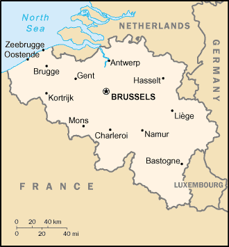
Location:
Western Europe, bordering the North Sea, between France and the
Netherlands
Area: Total: 30,510 sq km land: 30,230 sq km water: 280 sq km
Area - comparative: About the size of Maryland
Land boundaries: Total: 1,385 km border countries: France 620 km, Germany 167
km, Luxembourg 148 km, Netherlands 450 km
Coastline: 66 km
Climate and Terrain:
Climate: Temperate; mild winters, cool summers; rainy, humid, cloudy
Terrain: Flat coastal plains in northwest, central rolling hills, rugged
mountains of Ardennes Forest in southeast
Elevation extremes: Lowest point: North Sea 0 m highest point: Signal de
Botrange 694 m
Natural resources: Coal, natural gas
People:
Population: 10,274,595.
Ethnic groups: Fleming 58%, Walloon 31%, mixed or other 11%.
Religions: Roman Catholic 75%, Protestant or other 25%.
Languages: Dutch 60%, French 40%, German less than 1%, legally bilingual (Dutch
and French.).
Government type: Federal parliamentary democracy under a constitutional
monarch.
Government:
Capital: Brussels.
Independence: 4 October 1830 a provisional government declared independence
from the Netherlands.
Economy overview:
This modern private enterprise economy has capitalized on its central
geographic location, highly developed transport network, and diversified
industrial and commercial base. Industry is concentrated mainly in the populous
Flemish area in the north. With few natural resources, Belgium must import
substantial quantities of raw materials and export a large volume of
manufactures, making its economy unusually dependent on the state of world
markets. About three-quarters of its trade is with other EU countries.
Belgium's public debt is expected to fall to about 100% of GDP in 2002, and the
government has succeeded in balancing its budget. Belgium, together with 11 of
its EU partners, began circulating euro currency in January 2002.
GDP - composition by sector: Agriculture: 1.4% industry: 24% services: 74.6%.
Statistics:
Telephones - main lines in use: 4.769 million.
Telephones - mobile cellular: 974,494.
Radio broadcast stations: FM 79, AM 7.
Radios: 8.075 million.
Television broadcast stations: 25.
Televisions: 4.72 million.
Internet users: 2.807 million.
Railways: Total: 3,422 km.
Highways: Total: 145,774 km paved: 116,182 km, unpaved: 29,592 km.
Airports: 42.
Airports - with paved runways: 24, with unpaved runways: 18.
Return to Visiting Locations
|