|
Bolivia
Background:
Bolivia, named after independence fighter Simon BOLIVAR, broke away from
Spanish rule in 1825; much of its subsequent history has consisted of a series
of nearly 200 coups and counter-coups. Comparatively democratic civilian rule
was established in the 1980s, but leaders have faced difficult problems of
deep-seated poverty, social unrest, and drug production. Current goals include
attracting foreign investment, strengthening the educational system, continuing
the privatization program, and waging an anticorruption campaign.
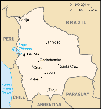
Location:
Central South America, southwest of Brazil
Area: Total: 1,098,580 sq km, water: 14,190 sq km, land: 1,084,390 sq km.
Area - comparative: Slightly less than three times the size of Montana.
Land boundaries: Total: 6,743 km, border countries: Argentina 832 km, Brazil
3,400 km, Chile 861 km, Paraguay 750 km, Peru 900 km.
Coastline: 0 km (landlocked).
Climate and Terrain:
Climate: Varies with altitude; humid and tropical to cold and semiarid.
Terrain: Rugged Andes Mountains with a highland plateau, hills, lowland plains
of the Amazon Basin.
Elevation extremes: Lowest point: Rio Paraguay 90 m, highest point: Nevado
Sajama 6,542 m.
Natural resources: Tin, natural gas, petroleum, zinc, tungsten, antimony,
silver, iron, lead, gold, timber, hydropower.
People:
Population: 8,445,134.
Ethnic groups: Quechua 30%, mestizo (mixed white and Amerindian ancestry) 30%,
Aymara 25%, white 15%.
Religions: Roman Catholic 95%, Protestant (Evangelical Methodist.)
Languages: Spanish (official), Quechua (official), Aymara (official).
Government:
Government type: Republic.
Capital: La Paz.
Independence: 6 August 1825 (from Spain).
Economy overview:
Bolivia, long one of the poorest and least developed Latin American
countries, has made considerable progress toward the development of a
market-oriented economy. Successes under President Sanchez De Lozada (1993-97)
included the signing of a free trade agreement with Mexico and becoming an
associate member of the Southern Cone Common Market (Mercosur), as well as the
privatization of the state airline, telephone company, railroad, electric power
company, and oil company. Growth slowed in 1999, in part due to tight
government budget policies, which limited needed appropriations for
anti-poverty programs, and the fallout from the Asian financial crisis. In
2000, major civil disturbances in April, and again in September and October,
held down overall growth to 2.5%. Bolivia's GDP failed to grow in 2001 due to
the global slowdown and laggard domestic activity. Growth is expected to pick
up in 2002, but the fiscal deficit and debt burden will remain high.
GDP - composition by sector: Agriculture: 14%, industry: 31%, services: 55%.
Statistics:
Telephones - main lines in use: 327,600.
Telephones - mobile cellular: 116,000.
Radio broadcast stations: AM 171, FM 73, shortwave 77.
Radios: 5.25 million.
Television broadcast stations: 48.
Televisions: 900,000.
Internet users: 78,000.
Railways: Total: 3,691 km.
Highways: Total: 49,400 km, paved: 2,500 km, unpaved: 46,900 km.
Airports: 1,109,
with paved runways: 12,
with unpaved runways: 1,069.
Return to Visiting Locations
|