|
British Indian Ocean Territory
Background:
Established as a territory of the UK in 1965, a number of the British Indian
Ocean Territory (BIOT) islands were transferred to the Seychelles when it
attained independence in 1976. Subsequently, BIOT has consisted only of the six
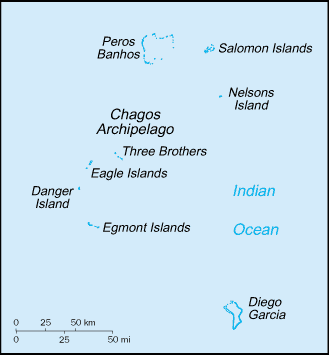
main island groups comprising the Chagos Archipelago. The largest and most
southerly of the islands, Diego Garcia, contains a joint UK-US naval support
facility. All of the remaining islands are uninhabited. Former agricultural
workers, earlier residents in the islands, were relocated primarily to
Mauritius but also to the Seychelles, between 1967 and 1973. In 2000, a British
High Court ruling invalidated the local immigration order that had excluded
them from the archipelago, but upheld the special military status of Diego
Garcia.
Location:
Location: Archipelago in the Indian Ocean, south of India, about one-half the
way from Africa to Indonesia.
Area: Total: 60 sq km, note: includes the entire Chagos Archipelago.
Area - comparative: About 0.3 times the size of Washington, DC
Coastline: 698 km.
Climate and Terrain:
Climate: Tropical marine; hot, humid, moderated by trade winds.
Terrain: Flat and low (most areas do not exceed four meters in elevation).
Elevation extremes: Lowest point: Indian Ocean 0 m, highest point: unnamed
location on Diego Garcia 15 m.
Natural resources: Coconuts, fish, sugarcane.
Geography - note: Archipelago of 2,300 islands; Diego Garcia, largest and
southernmost island, occupies strategic location in central Indian Ocean;
island is site of joint US-UK military facility.
People:
Population: no indigenous inhabitants. In 2001, there were approximately 1,500
UK and US military personnel and 2,000 civilian contractors living on the
island of Diego Garcia.
Government:
Dependency status: Overseas territory of the UK; administered by a
commissioner, resident in the Foreign and Commonwealth Office in London.
Legal system: The laws of the UK, where applicable, apply.
Economy overview:
All economic activity is concentrated on the largest island of Diego Garcia,
where joint UK-US defense facilities are located. Construction projects and
various services needed to support the military installations are done by
military and contract employees from the UK, Mauritius, the Philippines, and
the US. There are no industrial or agricultural activities on the islands. When
the Ilois return, they plan to reestablish sugarcane production and fishing.
Electricity - Electricity supplied by the US military.
Statistics:
Radio broadcast stations: AM 1, FM 2.
Television broadcast stations: 1.
Highways: Short section of paved road between port and airfield on Diego Garcia.
Ports and harbors: Diego Garcia.
Airports - with paved runways: 1.
Return to Visiting Locations
Hi Res Photo of Diego Garcia
|

