|
Burkina Faso
Background:
Independence from France came to Burkina Faso (formerly Upper Volta) in 1960.
Repeated military coups during the 1970s and 1980s were followed by multiparty
elections in the early 1990s. Burkina Faso's high population density and
limited natural resources result in poor economic prospects for the majority of
its citizens. Every year, several hundred thousand seasonal farm workers seek
employment in Cote d'Ivoire and Ghana and are adversely affected by instability
in those regions.
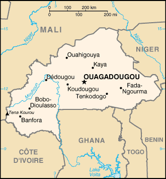
Location:
Location: Western Africa, north of Ghana.
Area: Total: 274,200 sq km, water: 400 sq km. land: 273,800 sq km.
Area - comparative: Slightly larger than Colorado
Land boundaries: Total: 3,193 km, border countries: Benin 306 km, Cote
d'Ivoire 584 km, Ghana 549 km, Mali 1,000 km, Niger 628 km, Togo 126 km.
Climate and Terrain:
Climate: Tropical; warm, dry winters; hot, wet summers.
Terrain: Mostly flat to dissected, undulating plains; hills in west and
southeast.
Natural resources: Manganese, limestone, marble; small deposits of gold,
antimony, copper, nickel, bauxite, lead, phosphates, zinc, silver.
People:
Population: 13,228,460.
Ethnic groups: Mossi over 40%, Gurunsi, Senufo, Lobi, Bobo, Mande, Fulani.
Religions: Indigenous beliefs 40%, Muslim 50%, Christian (mainly Roman
Catholic) 10%.
Languages: French (official), native African languages belonging to Sudanic
family spoken by 90% of the population.
Government:
Government type: Parliamentary republic.
Capital: Ouagadougou.
Economy overview:
One of the poorest countries in the world, landlocked Burkina Faso has few
natural resources, a fragile soil, and a highly unequal distribution of income.
About 90% of the population is engaged in (mainly subsistence) agriculture,
which is vulnerable to variations in rainfall. Industry remains dominated by
unprofitable government-controlled corporations. Following the African franc
currency devaluation in January 1994 the government updated its development
program in conjunction with international agencies, and exports and economic
growth have increased. Maintenance of macroeconomic progress depends on
continued low inflation, reduction in the trade deficit, and reforms designed
to encourage private investment. The internal crisis in neighboring Cote
d'Ivoire continues to hurt trade and industrial prospects and deepens the need
for international assistance.
Statistics:
Telephones - main lines in use: 53,200.
Telephones - mobile cellular: 25,200.
Radio broadcast stations: AM 3, FM 17, shortwave 3.
Radios: 394,020.
Television broadcast stations: 1.
Televisions: 131,340.
Internet users: 25,000.
Railways: Total: 622 km.
Highways: Total: 12,506 km, paved: 2,001 km, unpaved: 10,505 km.
Airports - with paved runways: 2,
with unpaved runways: 31.
Return to Visiting Locations
|