|
Cayman Islands
Background:
The Cayman Islands were colonized from Jamaica by the British
during the 18th and 19th centuries. Administered by Jamaica from 1863, they
remained a British dependency after 1962 when the former became independent.
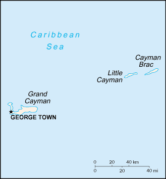
Location:
Caribbean, island group in Caribbean Sea, nearly one-half of the way
from Cuba to Honduras.
Area: Total: 259 sq km.
Area - comparative: 1.5 times the size of Washington, DC.
Coastline: 160 km.
Climate and Terrain:
Climate: Tropical marine; warm, rainy summers (May to October) and cool,
relatively dry winters (November to April).
Terrain: Low-lying limestone base surrounded by coral reefs.
Elevation extremes: Lowest point: Caribbean Sea 0 m highest point: The
Bluff 43 m.
Natural resources: fish, climate and beaches that foster tourism.
Land use: Arable land: 0% forests and woodland: 23%.
People:
Population: 35,527.
Ethnic groups: Mixed 40%, white 20%, black 20%, expatriates of various ethnic
groups 20%.
Religions: United Church (Presbyterian and Congregational), Anglican, Baptist,
Roman Catholic, Church of God, other Protestant.
Languages: English.
Government:
Government type: British crown colony.
Capital: George Town.
Economy overview:
With no direct taxation, the islands are a thriving
offshore financial center. More than 40,000 companies were registered in the
Cayman Islands as of 1997, including almost 600 banks and trust companies;
banking assets exceed $500 billion. A stock exchange was opened in 1997.
Tourism is also a mainstay, accounting for about 70% of GDP and 75% of foreign
currency earnings. The tourist industry is aimed at the luxury market and
caters mainly to visitors from North America. Total tourist arrivals exceeded
1.2 million visitors in 1997. About 90% of the islands' food and consumer goods
must be imported. The Caymanians enjoy one of the highest outputs per capita
and one of the highest standards of living in the world.
Industries: Tourism, banking, insurance and finance, construction, construction
materials, furniture.
Statistics:
Telephones - main lines in use: 19,000.
Telephones - mobile cellular: 2,534.
Radio broadcast stations: AM 1, FM 5.
Radios: 36,000.
Televisions: 7,000.
Highways: Total: 406 km paved: 304 km unpaved: 102 km.
Airports - with paved runways: 2 with unpaved runways: 1.
Return to Visiting Locations
|