|
Cook Islands
Background:
Named after Captain Cook, who sighted them in 1770, the islands
became a British protectorate in 1888. By 1900, administrative control was
transferred to New Zealand; in 1965 residents chose self-government in free
association with New Zealand. The emigration of skilled workers to New Zealand
and government deficits are continuing problems.
Location:
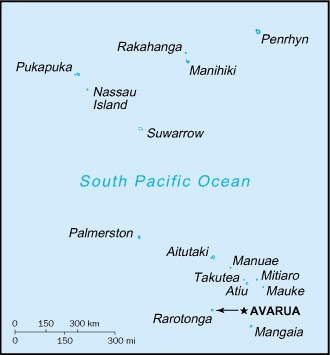
Oceania, group of islands in the South Pacific Ocean, about one-half
of the way from Hawaii to New Zealand. Area: total: 240 sq km.
1.3 times the size of Washington, DC. Coastline: 120 km.
Geography - note: the northern Cook Islands are seven low-lying, sparsely
populated, coral atolls; the southern Cook Islands consist of eight elevated,
fertile, volcanic isles where most of the populace lives
Climate and Terrain:
Climate: tropical; moderated by trade winds.
Terrain: low coral atolls in north; volcanic, hilly islands in south.
Elevation extremes: lowest point: Pacific Ocean 0 m, highest point: Te Manga
652 m.
Land use: arable land: 9% permanent crops: 13% permanent pastures: 0%
forests and woodland: 0% other: 78%.
People:
Population: 20,611.
Ethnic groups: Polynesian (full blood) 81.3%, Polynesian and European 7.7%,
Polynesian and non-European 7.7%, European 2.4%, other 0.9%.
Religions: Christian.
Languages: English (official), Maori.
Government:
Dependency status: Unincorporated and unorganized territory of the
US;
administered by the Office of Insular Affairs, US Department of the
Interior.
Capital: Pago Pago
Economy overview:
Like many other South Pacific island nations, the Cook
Islands' economic development is hindered by the isolation of the country from
foreign markets, the limited size of domestic markets, lack of natural
resources, periodic devastation from natural disasters, and inadequate
infrastructure. Agriculture provides the economic base with major exports made
up of copra and citrus fruit. Manufacturing activities are limited to fruit
processing, clothing, and handicrafts. Trade deficits are made up for by
remittances from emigrants and by foreign aid, overwhelmingly from New Zealand.
In the 1980s and 1990s, the country lived beyond its means, maintaining a
bloated public service and accumulating a large foreign debt. Subsequent
reforms, including the sale of state assets, the strengthening of economic
management, the encouragement of tourism, and a debt restructuring agreement,
have rekindled investment and growth.
Statistics:
Telephones - main lines in use: 5,000.
Radio broadcast stations: AM 1, FM 2.
Radios: 14,000.
Television broadcast stations: 2.
Televisions: 4,000.
Highways: total: 320 km.
Airports: 7, with paved runways: 1.
Return to Visiting Locations
|