|
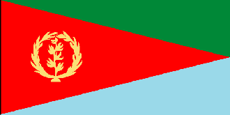
Eritrea
Background:
Eritrea was awarded to Ethiopia in 1952 as part of a federation.
Ethiopia's annexation of Eritrea as a province 10 years later sparked a 30-year
struggle for independence that ended in 1991 with Eritrean rebels defeating
governmental forces; independence was overwhelmingly approved in a 1993
referendum. A two and a half year border war with Ethiopia that erupted in 1998
ended on 12 December 2000.
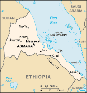
Location:
Eastern Africa, bordering the Red Sea, between Djibouti and Sudan.
Geographic coordinates: 15 00 N, 39 00 E.
Area: Total: 121,320 sq km land: 121,320 sq km water: 0 sq km.
Area - comparative: Slightly larger than Pennsylvania.
Land boundaries: Total: 1,630 km, border countries: Djibouti 113 km, Ethiopia
912 km, Sudan 605 km.
Coastline: 2,234 km total; mainland on Red Sea 1,151 km, islands in Red Sea
1,083 km.
Climate and Terrain:
Hot, dry desert strip along Red Sea coast; cooler and wetter in the
central highlands (up to 61 cm of rainfall annually); semiarid in western hills
and lowlands; rainfall heaviest during June-September except in coastal desert
Dominated by extension of Ethiopian north-south trending highlands,
descending on the east to a coastal desert plain, on the northwest to hilly
terrain and on the southwest to flat-to-rolling plains.
Natural resources: Gold, potash, zinc, copper, salt, possibly oil and natural
gas, fish.
Land use: Arable land: 12%, forests and woodland: 6%.
People:
Population: 4,298,269.
Ethnic groups: Ethnic Tigrinya 50%, Tigre and Kunama 40%, Afar 4%, Saho (Red
Sea coast dwellers) 3%.
Religions: Muslim, Coptic Christian, Roman Catholic, Protestant.
Languages: Afar, Amharic, Arabic, Tigre and Kunama, Tigrinya, other Cushitic
languages.
Government:
Government type: Republic.
Capital: Asmara (formerly Asmera).
Independence: 24 May 1993 (from Ethiopia).
Economy overview:
The economy
is largely based on subsistence agriculture, with 80% of the population
involved in farming and herding. The small industrial sector consists mainly of
light industries with outmoded technologies. Domestic output (GDP) is
substantially augmented by worker remittances from abroad. Government revenues
come from custom duties and taxes on income and sales. Road construction is a
top domestic priority
Agriculture - products: sorghum, lentils, vegetables, corn, cotton, tobacco,
coffee, sisal; livestock, goats; fish.
Statistics:
Telephones: 23,578.
Telephone system: very inadequate.
Radio broadcast stations: AM 2, FM 1, short-wave 2.
Radios: 345,000.
Television broadcast stations: 1.
Televisions: 1,000.
Internet users: 500.
Railways: Total: 317.
Highways: Total: 3,850 km, paved: 810 km, unpaved: 3,040 km.
Airports - paved runways: 2.
Airports - unpaved runways: 18.
Return to Visiting Locations
|