|
Guatemala
Background:
Guatemala was freed of Spanish colonial rule in 1821. During the second half of
the 20th century, it experienced a variety of military and civilian governments
as well as a 36-year guerrilla war. In 1996, the government signed a peace
agreement formally ending the conflict, which had led to the death of more than
100,000 people and had created some 1 million refugees.
Location:
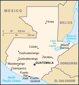
Middle America, bordering the Caribbean Sea, between Honduras and Belize and
bordering the North Pacific Ocean, between El Salvador and Mexico.
Area: Total: 108,890 sq km, water: 460 sq km, land: 108,430 sq km.
Area - comparative: Slightly smaller than Tennessee.
Land boundaries: Total: 1,687 km, border countries: Belize 266 km, El Salvador
203 km, Honduras 256 km, Mexico 962 km.
Coastline: 400 km.
Climate and Terrain:
Climate: Tropical; hot, humid in lowlands; cooler in highlands.
Terrain: Mostly mountains with narrow coastal plains and rolling limestone
plateau (Peten).
Elevation extremes: Lowest point: Pacific Ocean 0 m, highest point: Volcan
Tajumulco 4,211 m.
Natural resources: Petroleum, nickel, rare woods, fish, chicle, hydropower.
People:
Population: 13,314,079.
Ethnic groups: Mestizo (mixed Amerindian-Spanish or assimilated Amerindian - in
local Spanish called Ladino), approximately 55%, Amerindian or predominantly
Amerindian, approximately 43%, whites and others 2%.
Religions: Roman Catholic, Protestant, indigenous Mayan beliefs.
Languages: Spanish 60%, Amerindian languages 40% (more than 20 Amerindian
languages, including Quiche, Cakchiquel, Kekchi, Mam, Garifuna, and Xinca).
Government:
Government type: Constitutional democratic republic.
Capital: Guatemala.
Independence: 15 September 1821 (from Spain).
Economy overview:
The agricultural sector accounts for about one-fourth of GDP, two-thirds of
exports, and half of the labor force. Coffee, sugar, and bananas are the main
products. Former President ARZU (1996-2000) worked to implement a program of
economic liberalization and political modernization. The 1996 signing of the
peace accords, which ended 36 years of civil war, removed a major obstacle to
foreign investment. In 1998, Hurricane Mitch caused relatively little damage to
Guatemala compared to its neighbors. Ongoing challenges include increasing
government revenues, negotiating further assistance from international donors,
and increasing the efficiency and openness of both government and private
financial operations.
GDP - composition by sector: Agriculture: 23%, industry: 20%, services: 57%.
Statistics:
Telephones - main lines in use: 665,061.
Telephones - mobile cellular: 663,296.
Radio broadcast stations: AM 130, FM 487, shortwave 15.
Radios: 835,000.
Television broadcast stations: 26 (plus 27 repeaters).
Televisions: 1.323 million.
Internet users: 65,000.
Railways: Total: 884 km.
Highways: Total: 13,856 km, paved: 4,370 km, unpaved: 9,486 km.
Airports: 475, with paved runways: 11, with unpaved runways: 464.
Return to Visiting Locations
|