|
Guinea
Background:
Independent from France since 1958, Guinea did not hold democratic
elections until 1993 when Gen. Lansana Conte (head of the military government)
was elected president of the civilian government. He was reelected in 1998.
Unrest in Sierra Leone has spilled over into Guinea, threatening stability and
creating a humanitarian emergency.
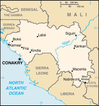
Location:
Western Africa, bordering the North Atlantic Ocean, between
Guinea-Bissau and Sierra Leone.
Geographic coordinates: 11 00 N, 10 00 W.
Area: total: 245,857 sq km.
Area - comparative: Slightly smaller than Oregon.
Land boundaries: Total: 3,399 km border countries: Cote d'Ivoire 610 km,
Guinea-Bissau 386 km, Liberia 563 km, Mali 858 km, Senegal 330 km, Sierra Leone
652 km. Coastline: 320 km.
Climate and Terrain:
Generally hot and humid; monsoonal-type rainy season (June to
November) with southwesterly winds; dry season (December to May) with
northeasterly harmattan winds.
Generally flat coastal plain, hilly to mountainous interior.
Elevation extremes: Lowest point: Atlantic Ocean 0 m, highest point: Mont
Nimba 1,752 m.
Natural resources: Bauxite, iron ore, diamonds, gold, uranium, hydropower,
fish.
Land use: Arable land: 2%; permanent crops, 0%, permanent pastures: 22%,
forests and woodland: 59%, other: 17%.
Irrigated land: 930 sq km.
Hot, dry, dusty harmattan haze may reduce visibility during dry season.
People:
Population: 7,613,870 (July 2001 est.)
Nationality: noun: Guinean(s) adjective: Guinean
Ethnic groups: Peuhl 40%, Malinke 30%, Soussou 20%, smaller ethnic groups 10%
Religions: Muslim 85%, Christian 8%, indigenous beliefs 7%
Languages: French (official), each ethnic group has its own language
Government:
Government type: Republic.
Capital: Conakry.
Independence: 2 October 1958 (from France).
Economy overview:
Guinea possesses major mineral, hydropower, and
agricultural resources, yet remains a poor underdeveloped nation. The country
possesses over 30% of the world's bauxite reserves and is the second largest
bauxite producer. The mining sector accounted for about 75% of exports in 1999.
However, escalating fighting along the Sierra Leonean and Liberian borders will
cause major economic disruptions.
Labor force: 3 million.
Labor force - by occupation: agriculture 80%, industry and services 20%.
Industries: bauxite, gold, diamonds; alumina refining; light manufacturing and
agricultural processing industries.
Statistics:
Telephones - main lines in use: 20,000.
Telephones - mobile cellular: 2,868.
Radio broadcast stations: AM 4, FM 8, short-wave 3.
Radios: 357,000.
Television broadcast stations: 6.
Televisions: 85,000.)
Internet users: 5,000.
Railways: Total: 1,086 km.
Highways: Total: 30,500 km, paved: 5,033 km, unpaved: 25,467 km.
Waterways: 1,295 km.
Airports - with paved runways: Total: 5.
Airports - with unpaved runways: Total: 10.
Return to Visiting Locations
|
