|
Hungary
Background:
Hungary was part of the polyglot Austro-Hungarian Empire, which collapsed
during World War I. The country fell under communist rule following World War
II. In 1956, a revolt and announced withdrawal from the Warsaw Pact were met
with a massive military intervention by Moscow. In the more open GORBACHEV
years, Hungary led the movement to dissolve the Warsaw Pact and steadily
shifted toward multiparty democracy and a market-oriented economy. Following
the collapse of the USSR in 1991, Hungary developed close political and
economic ties to Western Europe. It joined NATO in 1999 and is a frontrunner in
a future expansion of the EU.
|
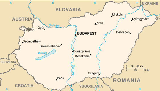
Climate and Terrain:
Climate: Temperate; cold, cloudy, humid winters; warm summers.
Terrain: Mostly flat to rolling plains; hills and low mountains on the
Slovakian border.
|
|
|
Economy overview:
Hungary continues to demonstrate strong economic growth and to work toward
accession to the European Union. The private sector accounts for over 80% of
GDP. Foreign ownership of and investment in Hungarian firms is widespread, with
cumulative foreign direct investment totaling more than $23 billion since 1989.
Hungarian sovereign debt was upgraded in 2000 to the second-highest rating
among all the Central European transition economies.
|
|