|
India
Background:
The Indus Valley civilization, one of the oldest in the world, goes back at
least 5,000 years. Aryan tribes from the northwest invaded about 1500 B.C.;
their merger with the earlier inhabitants created the classical Indian culture.
Arab incursions starting in the 8th century and Turkish in 12th were followed
by European traders beginning in the late 15th century. By the 19th century,
Britain had assumed political control of virtually all Indian lands. Nonviolent
resistance to British colonialism under Mohandas Gandhi and Jawaharlal Nehru
led to independence in 1947.
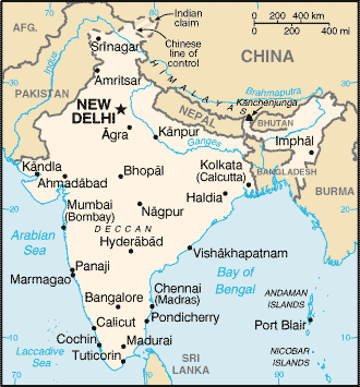
Location:
Southern Asia, bordering the Arabian Sea and the Bay of Bengal, between Burma
and Pakistan.
Area: Total: 3,287,590 sq km, land: 2,973,190 sq km, water: 314,400 sq km.
Area - comparative: Slightly more than one-third the size of the US.
Land boundaries: Total: 14,103 km, border countries: Bangladesh 4,053 km,
Bhutan 605 km, Burma 1,463 km, China 3,380 km, Nepal 1,690 km, Pakistan 2,912
km.
Coastline: 7,000 km.
Climate and Terrain:
Climate: Varies from tropical monsoon in south to temperate in north.
Terrain: Upland plain (Deccan Plateau) in south, flat to rolling plain along
the Ganges, deserts in west, Himalayas in north.
People:
Population: 1,045,845,226.
Ethnic groups: Indo-Aryan 72%, Dravidian 25%, Mongoloid and other 3%.
Religions: Hindu 81.3%, Muslim 12%, Christian 2.3%, Sikh 1.9%, other groups
including Buddhist, Jain, Parsi 2.5%.
Languages: English enjoys associate status but is the most important language
for national, political, and commercial communication; Hindu is the national
language and primary tongue of 30% of the people; there are 14 other official
languages.
Government:
Government type: Federal republic.
Capital: New Delhi.
Independence: 15 August 1947 (from UK).
Economy overview:
India's economy encompasses traditional village farming, modern agriculture,
handicrafts, a wide range of modern industries, and a multitude of support
services. About a quarter of the population is too poor to be able to afford an
adequate diet. India's international payments position remained strong in 2001
with adequate foreign exchange reserves, and moderately depreciating nominal
exchange rates. India has large numbers of well-educated
people skilled in English language; India is a major exporter of software
services and software workers.
GDP - composition by sector: Agriculture: 25%, industry: 26%, services: 49%.
Statistics:
Telephones - main lines in use: 27.7 million.
Telephones - mobile cellular: 2.93 million.
Radio broadcast stations: AM 153, FM 91, shortwave 68.
Radios: 116 million.
Television broadcast stations: 562.
Televisions: 63 million.
Internet users: 5 million.
Railways: Total: 63,693 km.
Highways: Total: 3,319,644 km, paved: 1,517,077 km, unpaved: 1,802,567 km.
Airports: 335, with paved runways: 234, with unpaved runways: 101.
Heliports: 18.
Return to Visiting Locations
|