|
Iraq
Background:
Formerly part of the Ottoman Empire, Iraq was occupied by Britain during the
course of World War I; in 1920, it was declared a League of Nations mandate
under UK administration. In stages over the next dozen years, Iraq attained its
independence as a kingdom in 1932. A "republic" was proclaimed in 1958, but in
actuality a series of military strongmen have ruled the country since then, the
latest being Saddam Husayn. Territorial disputes with Iran led to an
inconclusive and costly eight-year war (1980-88). In August 1990, Iraq seized
Kuwait, but was expelled by US-led, UN coalition forces during the Gulf War of
January-February 1991. Following Kuwait's liberation, the UN Security Council
(UNSC) required Iraq to scrap all weapons of mass destruction and long-range
missiles and to allow UN verification inspections. Continued Iraqi
noncompliance with UNSC resolutions over a period of 12 years resulted in the
US-led invasion of Iraq in March 2003 and the ouster of the Saddam Husayn
regime. Coalition forces remain in Iraq, helping to restore degraded
infrastructure and facilitating the establishment of a freely elected
government.
Location:
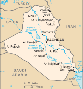
Location: Middle East, bordering the Persian Gulf, between Iran and Kuwait.
Area: Total: 437,072 sq km, water: 4,910 sq km, land: 432,162 sq km.
Area - comparative: Slightly more than twice the size of Idaho.
Land boundaries: Total: 3,650 km, border countries: Iran 1,458 km, Jordan 181
km, Kuwait 240 km, Saudi Arabia 814 km, Syria 605 km, Turkey 352 km.
Coastline: 58 km.
Climate and Terrain:
People:
Government:
Government type: In transition following April 2003 defeat of Saddam Husayn
regime by US-led coalition.
Capital: Baghdad.
Independence: 3 October 1932 (from League of Nations mandate under British
administration).
Economy overview:
Iraq's economy is dominated by the oil sector, which has traditionally
provided about 95% of foreign exchange earnings. In the 1980s financial
problems caused by massive expenditures in the eight-year war with Iran and
damage to oil export facilities by Iran led the government to implement
austerity measures, borrow heavily, and later reschedule foreign debt payments;
Iraq suffered economic losses from the war of at least $100 billion. After
hostilities ended in 1988, oil exports gradually increased with the
construction of new pipelines and restoration of damaged facilities. Iraq's
seizure of Kuwait in August 1990, subsequent international economic sanctions,
and damage from military action by an international coalition beginning in
January 1991 drastically reduced economic activity.
Statistics:
Telephones - main lines in use: 675,000.
Radio broadcast stations: AM 19 (5 are inactive), FM 51, shortwave 4.
Radios: 4.85 million.
Television broadcast stations: 13 (1997); note - unknown numbers were destroyed
during the March-April 2003 war.
Televisions: 1.75 million.
Internet users: 12,500.
Railways: Total: 1,963 km.
Highways: Total: 45,550 km, paved: 38,399 km, unpaved: 7,151 km.
Airports - with paved runways: 77.
Return to Visiting Locations
|