|
Ireland
Background:
A failed 1916 Easter Monday Rebellion touched off several years of guerrilla
warfare that in 1921 resulted in independence from the UK for the 26 southern
counties; the six northern counties (Ulster) remained part of Great Britain. In
1948 Ireland withdrew from the British Commonwealth; it joined the European
Community in 1973. Irish governments have sought the peaceful unification of
Ireland and have cooperated with Britain against terrorist groups. A peace
settlement for Northern Ireland, known as the Good Friday Agreement and
approved in 1998, is currently being implemented.
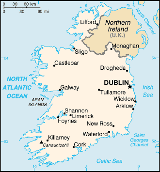
Location:
Western Europe, occupying five-sixths of the island of Ireland in the
North Atlantic Ocean, west of Great Britain.
Area: Total: 70,280 sq km, water: 1,390 sq km, land: 68,890 sq km.
Area - comparative: Slightly larger than West Virginia.
Land boundaries: Total: 360 km, border countries: UK 360 km.
Coastline: 1,448 km.
Climate and Terrain:
Climate: Temperate maritime; modified by North Atlantic Current; mild winters,
cool summers; consistently humid; overcast about half the time.
Terrain: Mostly level to rolling interior plain surrounded by rugged hills and
low mountains; sea cliffs on west coast.
People:
Population: 3,883,159.
Ethnic groups: Celtic, English.
Religions: Roman Catholic 91.6%, Church of Ireland 2.5%, other 5.9%.
Languages: English is the language generally used, Irish (Gaelic) spoken mainly
in areas located along the western seaboard.
Government:
Government type: Republic.
Capital: Dublin.
Independence: 6 December 1921 (from UK by treaty).
Economy overview:
Ireland is a small, modern, trade-dependent economy with growth averaging a
robust 9% in 1995-2001. Agriculture, once the most important sector, is now
dwarfed by industry, which accounts for 38% of GDP, about 80% of exports, and
employs 28% of the labor force. Although exports remain the primary engine for
Ireland's robust growth, the economy is also benefiting from a rise in consumer
spending and recovery in both construction and business investment. Over the
past decade, the Irish government has implemented a series of national economic
programs designed to curb inflation, reduce government spending, increase labor
force skills, and promote foreign investment. Ireland joined in launching the
euro currency system in January 1999 along with 10 other EU nations. T
GDP - composition by sector: Agriculture: 4%, industry: 38%. services: 58%.
Statistics:
Telephones - main lines in use: 1.59 million.
Telephones - mobile cellular: 2 million.
Radio broadcast stations: AM 9, FM 106.
Radios: 2.55 million.
Television broadcast stations: 4.
Televisions: 1.82 million.
Internet users: 1.25 million.
Railways: Total: 3,314 km.
Highways: Total: 92,500 km, paved: 87,043 km. unpaved: 5,457 km.
Airports: 41, with paved runways: 17, with unpaved runways: 24.
Return to Visiting Locations
|