|
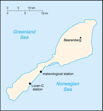
Jan Mayen Island
Background:
This desolate, mountainous island was named after a Dutch whaling captain who
indisputably discovered it in 1614 (earlier claims are inconclusive). Visited
only occasionally by seal hunters and trappers over the following centuries,
the island came under Norwegian sovereignty in 1929. The long dormant Haakon
VII Toppen/Beerenberg volcano resumed activity in 1970; it is the northernmost
active volcano on earth.
Location:
Location: Northern Europe, island between the Greenland Sea and the Norwegian
Sea, northeast of Iceland.
Area: total: 373 sq km.
Area - comparative: Slightly more than twice the size of Washington, DC.
Coastline: 124.1 km.
Climate and Terrain:
Climate: Arctic maritime with frequent storms and persistent fog.
Terrain: Volcanic island, partly covered by glaciers.
Geography - note: Barren volcanic island with some moss and grass.
People:
No indigenous inhabitants. Note: personnel operate the Long Range
Navigation (Loran-C) base and the weather and coastal services radio station.
Government:
Dependency status: Territory of Norway; since August 1994, administered from
Oslo through the county governor (fylkesmann) of Nordland; however, authority
has been delegated to a station commander of the Norwegian Defense
Communication Service.
Economy overview:
Jan Mayen is a volcanic island with no exploitable natural
resources. Economic activity is limited to providing services for employees of
Norway's radio and meteorological stations located on the island.
Statistics:
Radio broadcast stations: Note: there is one radio and meteorological station
(1998)
Ports and harbors: None; offshore anchorage only.
Airports: 1
with unpaved runway.:
Return to Visiting Locations
|