|
Kenya
Background:
Revered president and liberation struggle icon Jomo Kenyatta led Kenya from
independence until his death in 1978, when current President Daniel Toroitich
arap Moi took power in a constitutional succession. The country was a de facto
one-party state from 1969 until 1982 when the ruling Kenya African National
Union (KANU) made itself the sole legal party in Kenya. Moi acceded to internal
and external pressure for political liberalization in late 1991.
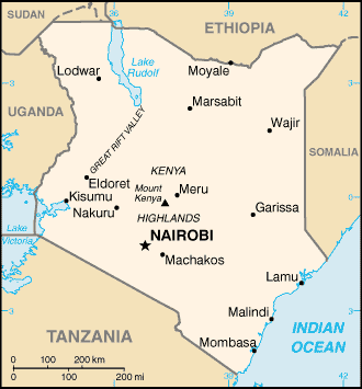
Location:
Eastern Africa, bordering the Indian Ocean, between Somalia and
Tanzania.
Area: Total: 582,650 sq km, land: 569,250 sq km, water: 13,400 sq km.
Area - comparative: Slightly more than twice the size of Nevada.
Land boundaries: Total: 3,446 km, border countries: Ethiopia 830 km, Somalia
682 km, Sudan 232 km, Tanzania 769 km, Uganda 933 km.
Coastline: 536 km.
Climate and Terrain:
Climate: Varies from tropical along coast to arid in interior.
Terrain: Low plains rise to central highlands bisected by Great Rift Valley;
fertile plateau in west.
Elevation extremes: Lowest point: Indian Ocean 0 m, highest point: Mount
Kenya 5,199 m.
Natural resources: Gold, limestone, soda ash, salt barites, rubies, fluorspar,
garnets, wildlife, hydropower.
Land use: Arable land: 7%, forests and woodland: 30%.
People:
Population: 30,765,916.
Ethnic groups: Kikuyu 22%, Luhya 14%, Luo 13%, Kalenjin 12%, Kamba 11%, Kisii
6%, Meru 6%, other African 15%, non-African (Asian, European, and Arab) 1%
Religions: Protestant 38%, Roman Catholic 28%, indigenous beliefs 26%, Muslim
7%, other 1% .
Languages: English (official).
Government:
Government type: Republic.
Capital: Nairobi.
Economy overview:
Kenya is well placed to serve as an engine of growth in
East Africa, but its economy has been stagnating because of poor management and
uneven commitment to reform. A new
economic team was put in place in 1999 to revitalize
the reform effort, strengthen the civil service, and curb corruption.
Long-term barriers to development include electricity shortages, inefficient
government dominance of key sectors, endemic corruption, and high population
growth.
GDP - composition by sector: Agriculture: 25% industry: 13% services: 62%.
Labor force - by occupation: Agriculture 75%-80%.
Unemployment rate: 50%.
Industries: Small-scale consumer goods (plastic, furniture, batteries,
textiles, soap, cigarettes, flour), agricultural products processing; oil
refining, cement; tourism.
Statistics:
Telephones - main lines in use: 290,000.
Telephones - mobile cellular: 5,345.
Radio broadcast stations: AM 24, FM 8.
Radios: 3.07 million.
Television broadcast stations: 8.
Televisions: 730,000.
Internet users: 45,000.
Railways: 2,778 km
Highways: Total: 63,800 km, paved: 8,868 km, unpaved: 54,932 km.
Airports - with paved runways: 22, unpaved runways: 208.
Return to Visiting Locations
|