|
Kiribati
Background:
The Gilbert Islands were granted self-rule by the UK in 1971 and
complete independence in 1979 under the new name of Kiribati.
Location:
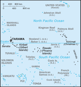
Oceania, group of islands in the Pacific Ocean, straddling the
equator, about one-half of the way from Hawaii to Australia; note - on 1
January 1995, Kiribati proclaimed that all of its territory lies in the same
time zone as its Gilbert Islands group (GMT +12) even though the Phoenix
Islands and the Line Islands under its jurisdiction lie on the other side of
the International Date Line.
Geographic coordinates: 1 25 N, 173 00 E.
Area: Total: 717 sq km. land: Note: includes three island groups
- Gilbert Islands, Line Islands, Phoenix Islands.
Area - comparative: Four times the size of Washington, DC.
Coastline: 1,143 km.
Climate and Terrain:
Tropical; marine, hot and humid, moderated by trade winds.
Mostly low-lying coral atolls surrounded by extensive reefs.
Elevation extremes: Lowest point: Pacific Ocean 0 m. Highest point: unnamed
location on Banaba 81 m.
Natural resources: Phosphate (production discontinued in 1979).
Land use: Arable land: 0%. permanent crops: 51%, permanent pastures: 0%.
forests and woodland: 3%. other: 46% (1993 est.).
Geography - note: 20 of the 33 islands are inhabited.
People:
Population: 94,149.
Population growth rate: 2.31%.
Ethnic groups: Predominantly Micronesian with some Polynesian.
Religions: Roman Catholic 54%, Protestant 30%.
Languages: English (official), I-Kiribati.
Government:
Government type: Republic.
Capital: Tarawa.
Independence: 12 July 1979 (from UK).
Economy overview:
A remote country of 33 scattered coral atolls, Kiribati has
few national resources. Commercially viable phosphate deposits were exhausted
at the time of independence from the UK in 1979. Economic development is
constrained by a shortage of skilled workers,
weak infrastructure, and remoteness from international markets. Tourism
provides more than one-fifth of GDP. Agriculture - products: copra, taro,
breadfruit, sweet potatoes, vegetables;
fish.
Statistics:
Telephones - main lines in use: 2,000.
Radio broadcast stations: AM 1, FM 1.
Radios: 17,000.
Television broadcast stations: 1.
Televisions: 1,000.
Internet users: 1,000.
Highways: Total: 670 km.
Airports - with paved runways: 4, with unpaved runways: 17.
Return to Visiting Locations
|