|
Kyrgyzstan
Background:
A Central Asian country of incredible natural beauty and proud
nomadic traditions, Kyrgyzstan was annexed by Russia in 1864; it achieved
independence from the Soviet Union in 1991
Location:
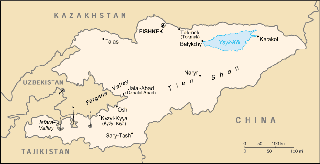
Central Asia, west of China
Area: Total: 198,500 sq km land: 191,300 sq km water: 7,200 sq km
Area - comparative: Slightly smaller than South Dakota
Land boundaries: total: 3,878 km border countries: China 858 km, Kazakhstan
1,051 km, Tajikistan 870 km, Uzbekistan 1,099 km
Climate and Terrain:
Climate: Dry continental to polar in high Tien Shan; subtropical in southwest
(Fergana Valley); temperate in northern foothill zone.
Terrain: Peaks of Tien Shan and associated valleys and basins encompass entire
nation. Elevation extremes: Lowest point: Kara-Daryya 132 m highest
point: Jengish Chokusu7,439 m.
Land use: Arable land: 7%, 44%, forests and woodland: 4% , other: 45%.
note: Kyrgyzstan has the world's largest natural growth walnut forest
Return to Visiting Locations
|
People:
Population: 4,753,003.
Ethnic groups: Kirghiz 52.4%, Russian 18%, Uzbek 12.9%, Ukrainian 2.5%, German
2.4%, other 11.8%
Religions: Muslim 75%, Russian Orthodox 20%, other 5%.
Languages: Kirghiz, Russian.
Government:
Government type: Republic .
Capital: Bishkek.
Economy overview:
Kyrgyzstan is a small, poor, mountainous country with a
predominantly agricultural economy. Cotton, wool, and meat are the main
agricultural products and exports. Industrial exports include gold, mercury,
uranium, and electricity. Kyrgyzstan has been one of the most progressive
countries of the former Soviet Union in carrying out market reforms. Much of the
government's stock in enterprises has been sold.
Statistics:
Telephones - main lines in use: 351,000.
Radio broadcast stations: AM, FM 14, shortwave 2.
Radios: 520,000.
Televisions: 210,000.
Internet users: 10,000.
Railways: Total: 370 km.
Highways: Total: 18,500 km.
Airports: paved runways: 4, unpaved runways: 46.
|