|
Lebanon
Background:
Lebanon has made progress toward rebuilding its political institutions since
1991 and the end of the devastating 16-year civil war. Under the Ta'if Accord -
the blueprint for national reconciliation - the Lebanese have established a
more equitable political system, particularly by giving Muslims a greater say
in the political process while institutionalizing sectarian divisions in the
government. Since the end of the war, the Lebanese have conducted several
successful elections, most of the militias have been weakened or disbanded, and
the Lebanese Armed Forces (LAF) have extended central government authority over
about two-thirds of the country. Hizballah, the radical Shi'a party, retains
its weapons. Syria maintains about 20,000 troops in Lebanon based mainly in
Beirut, North Lebanon, and the Bekaa Valley.
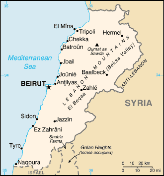
Location:
Middle East, bordering the Mediterranean Sea, between Israel and Syria.
Area: Total: 10,400 sq km, water: 170 sq km, land: 10,230 sq k.m
Area - comparative: About 0.7 times the size of Connecticut.
Land boundaries: Total: 454 km, border countries: Israel 79 km, Syria 375 km.
Coastline: 225 km.
Climate and Terrain:
Climate: Mediterranean; mild to cool, wet winters with hot, dry summers;
Lebanon mountains experience heavy winter snows.
Terrain: Narrow coastal plain; El Beqaa (Bekaa Valley) separates Lebanon and
Anti-Lebanon Mountains.
Natural resources: Limestone, iron ore, salt, water-surplus state in a
water-deficit region, arable land.
People:
Population: 3,677,780.
Ethnic groups: Arab 95%, Armenian 4%, other 1%.
Religions: Muslim 70% (including Shi'a, Sunni, Druze, Isma'ilite, Alawite or
Nusayri), Christian 30% (including Orthodox Christian, Catholic, Protestant),
Jewish NEGL%.
Languages: Arabic (official), French, English, Armenian.
Government:
Government type: Republic.
Capital: Beirut.
Independence: 22 November 1943 (from League of Nations mandate under French
administration).
Economy overview:
The 1975-91 civil war seriously damaged Lebanon's economic infrastructure, cut
national output by half, and all but ended Lebanon's position as a Middle
Eastern entrepot and banking hub. Peace enabled the central government to
restore control in Beirut, begin collecting taxes, and regain access to key
port and government facilities. Economic recovery was helped by a financially
sound banking system and resilient small- and medium-scale manufacturers.
GDP - composition by sector: Agriculture: 12%, industry: 21%, services: 67%.
Statistics:
Telephones - main lines in use: 700,000.
Telephones - mobile cellular: 580,000.
Radio broadcast stations: AM 20, FM 22, shortwave 4.
Radios: 2.85 million.
Television broadcast stations: 15 (plus 5 repeaters).
Televisions: 1.18 million.
Internet users: 300,000.
Railways: Total: 399 km.
Highways: Total: 7,300 km, paved: 6,350 km, unpaved: 950 km.
Airports: 8, with paved runways: 5, with unpaved runways: 3.
Return to Visiting Locations
|