|
Lesotho
Background:
Basutoland was renamed the Kingdom of Lesotho upon independence from the UK in
1966. King Moshoeshoe was exiled in 1990. Constitutional government was
restored in 1993 after 23 years of military rule.
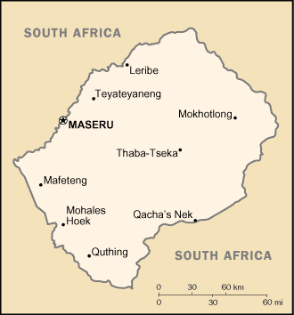
Location:
Southern Africa, an enclave of South Africa.
Area: Total: 30,355 sq km, water: 0 sq km, land: 30,355 sq km.
Area - comparative: Slightly smaller than Maryland.
Land boundaries: Total: 909 km, border countries: South Africa 909 km.
Coastline: 0 km (landlocked).
Climate and Terrain:
Climate: Temperate; cool to cold, dry winters; hot, wet summers.
Terrain: Mostly highland with plateaus, hills, and mountains.
Natural resources: Water, agricultural and grazing land, some diamonds and
other minerals.
People:
Population: 2,207,954.
Ethnic groups: Sotho 99.7%, Europeans, Asians, and other 0.3%,
Religions: Christian 80%, indigenous beliefs 20%.
Languages: Sesotho (southern Sotho), English (official), Zulu, Xhosa.
Government:
Government type: Parliamentary constitutional monarchy.
Capital: Maseru.
Independence: 4 October 1966 (from UK).
Economy overview:
Small, landlocked, and mountainous, Lesotho's primary natural resource is
water. Its economy is based on subsistence agriculture, livestock, remittances
from miners employed in South Africa, and a rapidly growing apparel-assembly
sector. The number of mineworkers has declined steadily over the past several
years. A small manufacturing base depends largely on farm products that support
the milling, canning, leather, and jute industries. Agricultural products are
exported primarily to South Africa. Proceeds from membership in a common
customs union with South Africa form the majority of government revenue.
Although drought has decreased agricultural activity over the past few years,
completion of a major hydropower facility in January 1998 now permits the sale
of water to South Africa, generating royalties for Lesotho. The pace of
privatization has increased in recent years. In December 1999, the government
embarked on a nine-month IMF staff-monitored program aimed at structural
adjustment and stabilization of macroeconomic fundamentals. The government is
in the process of applying for a three-year successor program with the IMF
under its Poverty Reduction and Growth Facility. Lesotho has a marked
inequality in income distribution and serious unemployment/underemployment
problems that will not yield to short-run solutions.
GDP - composition by sector: Agriculture: 18%, industry: 38%, services: 44%.
Statistics:
Telephones - main lines in use: 22,200.
Telephones - mobile cellular: 21,600.
Radio broadcast stations: AM 1, FM 2, shortwave 1.
Television broadcast stations: 1.
Internet users: 4,000.
Railways: Total: 2.6 km; note - owned by, operated by, and included in the
statistics of South Africa.
Highways: Total: 4,955 km, paved: 887 km, unpaved: 4,068 km.
Airports: 28, with paved runways: 4, with unpaved runways: 24.
Return to Visiting Locations
|