|
Mali
Background:
The Sudanese Republic and Senegal became independent of France in 1960 as the
Mali Federation. When Senegal withdrew after only a few months, the Sudanese
Republic was renamed Mali. Rule by dictatorship was brought to a close in 1991
with a transitional government, and in 1992 when Mali's first democratic
presidential election was held. Since his reelection in 1997, President KONARE
continued to push through political and economic reforms and to fight
corruption. In 1999 he indicated he would not run for a third term, in keeping
with the Malian constitution's two-term limit.
1990.
Location:
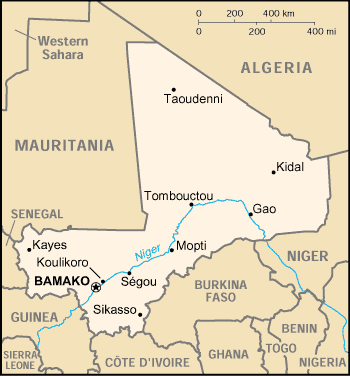
Location: Western Africa, southwest of Algeria
Area: Total: 1.24 million sq km, water: 20,000 sq km, land: 1.22 million sq
km.
Area - comparative: Slightly less than twice the size of Texas
Land boundaries: Total: 7,243 km, border countries: Algeria 1,376 km, Burkina
Faso 1,000 km, Guinea 858 km, Cote d'Ivoire 532 km, Mauritania 2,237 km, Niger
821 km, Senegal 419 km.
Climate and Terrain:
Climate: Subtropical to arid; hot and dry February to June; rainy, humid, and
mild June to November; cool and dry November to February.
Terrain: Mostly flat to rolling northern plains covered by sand; savanna in
south, rugged hills in northeast.
Elevation extremes: Lowest point: Senegal River 23 m, highest point: Hombori
Tondo 1,155 m.
Natural resources: Gold, phosphates, kaolin, salt, limestone, uranium,
hydropower note: bauxite, iron ore, manganese, tin, and copper deposits are
known but not exploited
People:
Population: 11,340,480.
Ethnic groups: Mande 50% (Bambara, Malinke, Soninke), Peul 17%, Voltaic 12%,
Songhai 6%, Tuareg and Moor 10%, other 5%.
Religions: Muslim 90%, indigenous beliefs 9%, Christian 1%.
Languages: French (official), Bambara 80%, numerous African languages.
Government:
Government type: Republic.
Capital: Bamako.
Independence: 22 September 1960 (from France).
Economy overview:
Mali is among the poorest countries in the world, with 65% of its land area
desert or semidesert. Economic activity is largely confined to the riverine
area irrigated by the Niger. About 10% of the population is nomadic and some
70% of the labor force is engaged in farming and fishing. Industrial activity
is concentrated on processing farm commodities. Mali is heavily dependent on
foreign aid and vulnerable to fluctuations in world prices for cotton, its main
export. In 1997, the government continued its successful implementation of an
IMF-recommended structural adjustment program that is helping the economy grow,
diversify, and attract foreign investment.
GDP - composition by sector: Agriculture: 45%, industry: 17%, services: 38%.
Statistics:
Telephones - main lines in use: 45,000.
Telephones - mobile cellular: 40,000.
Radio broadcast stations: AM 1, FM 28, shortwave 1.
Radios: 570,000.
Television broadcast stations: 1.
Televisions: 45,000.
Internet users: 10,000.
Railways: Total: 729 km.
Highways: Total: 15,100 km, paved: 1,827 km. unpaved: 13,273 km.
Airports: 27.
Airports - with paved runways: 7, with unpaved runways: 20.
Return to Visiting Locations
|