|
Marshall Islands
Background:
After almost four decades under US administration as the easternmost part of
the UN Trust Territory of the Pacific Islands, the Marshall Islands attained
independence in 1986 under a Compact of Free Association. Compensation claims
continue as a result of US nuclear testing on some of the atolls between 1947
and 1962. The Marshall Islands have been home to the US Army Base Kwajalein
(USAKA) since 1964.
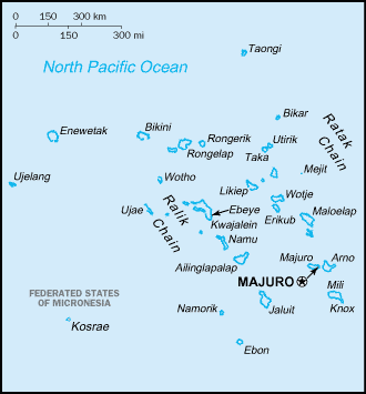
Location:
Location: Oceania, group of atolls and reefs in the North Pacific Ocean, about
one-half of the way from Hawaii to Australia.
Area: Total: 181.3 sq km note: includes the atolls of Bikini, Enewetak,
Kwajalein, Majuro, Rongelap, and Utirik .
Area - comparative: About the size of Washington, DC.
Coastline: 370.4 km.
Climate and Terrain:
Climate: Wet season from May to November; hot and humid; islands border typhoon
belt.
Terrain: Low coral limestone and sand islands.
Elevation extremes: Lowest point: Pacific Ocean 0 m , highest point: unnamed
location on Likiep 10 m.
Geography - note: Two archipelagic island chains of 30 atolls and 1,152
islands;
People:
Population: 56,429.
Ethnic groups: Micronesian.
Religions: Christian (mostly Protestant).
Languages: English (widely spoken as a second language, both English and
Marshallese are official languages).
Government type: Constitutional government in free association with the US.
Capital: Majuro.
Independence: 21 October 1986 (from the US-administered UN trusteeship).
Government:
Government type: Constitutional government in free association with the US; the
Compact of Free Association entered into force 21 October 1986.
Capital: Majuro.
Independence: 21 October 1986 (from the US-administered UN trusteeship).
Economy overview:
US Government assistance is the mainstay of this tiny island economy.
Agricultural production is primarily subsistence and is concentrated on small
farms; the most important commercial crops are coconuts and breadfruit.
Small-scale industry is limited to handicrafts, tuna processing, and copra. The
tourist industry, now a small source of foreign exchange employing less than
10% of the labor force, remains the best hope for future added income. The
islands have few natural resources, and imports far exceed exports. Under the
terms of the Compact of Free Association, the US has provided more than $1
billion in aid since 1986. Negotiations have continued for an extended
agreement.
Statistics:
Telephones - main lines in use: 4,186.
Telephones - mobile cellular: 489.
Radio broadcast stations: AM 2, FM 1.
Television broadcast stations: 2 (both are US military stations).
Internet users: 900.
Airports - with paved runways: 4, with unpaved runways: 11.
Return to Visiting Locations
|