|
Mauritius
Background:
Discovered by the Portuguese in 1505, Mauritius was subsequently
held by the Dutch, French, and British before independence was attained in
1968. A stable democracy with regular free elections and a positive human
rights record, the country has attracted considerable foreign investment and
has earned one of Africa's highest per capita incomes. Recent poor weather and
declining sugar prices have slowed economic growth leading to some protests
over standards of living in the Creole community.
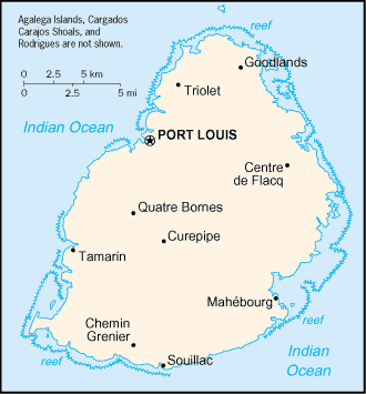
Location:
Southern Africa, island in the Indian Ocean, east of Madagascar.
Geographic coordinates: 20 17 S, 57 33 E.
Area: Total: 1,860 sq km, land: 1,850 sq km, water: 10 sq km, Note: includes
Agalega Islands, Cargados Carajos Shoals (Saint Brandon), and
Rodrigues.
Area - comparative: Almost 11 times the size of Washington, DC.
Coastline: 177 km .
Climate and Terrain:
Tropical, modified by southeast trade winds; warm, dry winter (May to
November); hot, wet, humid summer (November to May).
Small coastal plain rising to discontinuous mountains encircling
central plateau.
Elevation extremes: Lowest point: Indian Ocean 0 m, highest point: Mont Piton
828 m.
Natural resources: Arable land, fish.
Land use: Arable land: 49%, permanent crops: 3%, permanent pastures: 3%,
forests and woodland: 22%, other: 23% (1993 est.).
Irrigated land: 170 sq km (1993 est.).
People:
Population: 1,189,825 (July 2001 est.).
Ethnic groups: Indo-Mauritian 68%, Creole 27%, Sino-Mauritian 3%,
Franco-Mauritian 2%.
Religions: Hindu 52%, Christian 28.3% (Roman Catholic 26%, Protestant 2.3%),
Muslim 16.6%, other 3.1%.
Languages: English (official), Creole, French, Hindi, Urdu, Hakka, Bojpoori.
Government:
Parliamentary democracy.
Capital: Port Louis.
Independence: 12 March 1968 (from UK).
Economy overview:
Since independence in 1968, Mauritius has developed from a
low-income, agriculturally based economy to a middle-income diversified economy
with growing industrial, financial, and tourist sectors. For most of the
period, annual growth has been in the order of 5% to 6%. This remarkable
achievement has been reflected in increased life expectancy, lowered infant
mortality, and a much-improved infrastructure. Sugarcane is grown on about 90%
of the cultivated land area and accounts for 25% of export earnings.
Statistics:
Telephones - main lines in use: 223,000.
Telephones - mobile cellular: 37,000.
Radio broadcast stations: AM 5, FM 9, short-wave 2.
Radios: 420,000.
Television broadcast stations: 2 (plus 11 repeaters).
Televisions: 258,000.
Internet country code: .mu.
Internet Service Providers (ISPs): 2.
Internet users: 55,000.
Railways: 0 km.
Highways: Total: 1,910 km, paved: 1,834 km (including 36 km of expressways),
unpaved: 76 km.
Airports - with paved runways: Total: 2.
Airports - with unpaved runways: Total: 3.
Return to Visiting Locations
|