|
Nepal
Background:
In 1951, the Nepalese monarch ended the century-old system of rule by
hereditary premiers and instituted a cabinet system of government. Reforms in
1990 established a multiparty democracy within the framework of a
constitutional monarchy. The refugee issue of some 100,000 Bhutanese in Nepal
remains unresolved; 90% of these displaced persons are housed in seven United
Nations Offices of the High Commissioner for Refugees (UNHCR) camps.
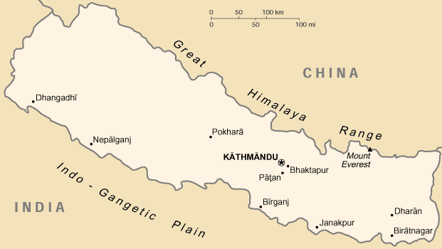
Location:
Southern Asia, between China and India.
Area: Total: 140,800 sq km, water: 4,000 sq km, land: 136,800 sq km.
Area - comparative: Slightly larger than Arkansas.
Land boundaries: Total: 2,926 km, border countries: China 1,236 km, India
1,690 km.
Climate and Terrain:
Climate: Varies from cool summers and severe winters in north to subtropical
summers and mild winters in south.
Terrain: Flat river plain of the Ganges in south, central hill region, rugged
Himalayas in north.
Elevation extremes: Lowest point: Kanchan Kalan 70 m, highest point: Mount
Everest 8,850m.
Return to Visiting Locations
|

People:
Population: 25,873,917.
Ethnic groups: Brahman, Chetri, Newar, Gurung, Magar, Tamang, Rai, Limbu,
Sherpa, Tharu, and others.
Religions: Hinduism 86.2%, Buddhism 7.8%, Islam 3.8%, other 2.2% note: only
official Hindu state in the world.
Languages: Nepali (official; spoken by 90% of the population), about a dozen
other languages and about 30 major dialects; note - many in government and
business also speak English.
Government:
Government type: Parliamentary democracy and constitutional monarchy.
Capital: Kathmandu.
Economy overview:
Nepal is among the poorest and least developed countries in the world with
nearly half of its population living below the poverty line. Agriculture is the
mainstay of the economy, providing a livelihood for over 80% of the population
and accounting for 41% of GDP. Security concerns in the wake of Maoist
activity, the June massacre of many members of the royal family, and the
September 11 terrorist attacks in the US led to a decrease in tourism, another
key source of foreign exchange. Agricultural production is growing by about 5%
on average as compared with annual population growth of 2.3%.
Statistics:
Telephones - main lines in use: 236,816.
Radio broadcast stations: AM 6, FM 5.
Radios: 840,000.
Television broadcast stations: 1.
Televisions: 130,000.
Internet users: 50,000.
Railways: Total: 59 km.
Highways: Total: 13,223 km, paved: 4,073 km, unpaved: 9,150 km.
Airports - with paved runways: 8, with unpaved runways: 37.
|