|
Norfolk Island
Background:
Background: Two British attempts at establishing the island as a penal colony
(1788-1814 and 1825-55) were ultimately abandoned. In 1856, Pitcairn Islanders,
descendants of the Bounty mutineers and their Tahitian companions, resettled
the island.
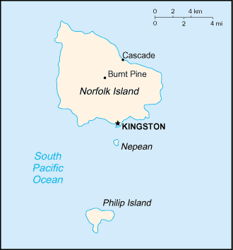
Location:
Oceania, island in the South Pacific Ocean, east of Australia.
Geographic coordinates: 29 02 S, 167 57 E.
Map references: Oceania.
Area: Total: 34.6 sq km.
Area - comparative: About 0.2 times the size of Washington, DC.
Coastline: 32 km.
Climate and Terrain:
Subtropical, mild, little seasonal temperature variation.
Volcanic formation with mostly rolling plains.
Elevation extremes: Lowest point: Pacific Ocean 0 m, highest point: Mount
Bates 319 m.
Natural resources: Fish.
Land use: Arable land: 0%,permanent pastures: 25%, other: 75%.
Natural hazards: typhoons (especially May to July).
People:
Population: 1,879.
Population growth rate: -0.71% (2001 est.).
Ethnic groups: Descendants of the Bounty mutineers, Australian, New Zealander,
Polynesians.
Religions: Anglican 39%, Roman Catholic 11.7%, Uniting Church in Australia
16.4%, Seventh-Day Adventist 4.4%, none 9.2%, unknown 16.9%, other 2.4% (1986).
Languages: English (official), Norfolk a mixture of 18th century English and
ancient Tahitian.
Government:
Capital: Kingston. Territory of Australia; Canberra administers Commonwealth
responsibilities on Norfolk Island through the Department of Environment,
Sport, and Territories
Economy overview:
Tourism, the primary economic activity, has steadily
increased over the years and has brought a level of prosperity unusual among
inhabitants of the Pacific islands. The agricultural sector has become
self-sufficient in the production of beef, poultry, and eggs.
Agriculture - products: Norfolk Island pine seed, Kentia palm seed, cereals,
vegetables, fruit; cattle, poultry.
Statistics:
Telephones - main lines in use: 1,087.
Telephones - mobile cellular: 0.
Radio broadcast stations: AM 0, FM 3.
Radios: 2,500 (1996)
Television broadcast stations: 1 (local programming station plus two repeaters
that bring in Australian programs by satellite).
Televisions: 1,200.
Railways: 0 km .
Highways: Total: 80 km, paved: 53 km, unpaved: 27 km.
Airports - with paved runways: 1.
Return to Visiting Locations
|