|
Statistics:
Telephones - main lines in use: 95,729. Radio broadcast stations: AM 1, FM 0.
Internet users: 23,520.
Highways: total: 4,500 km paved: 2,700 km unpaved:
Airports: 3.
|
Palestinian-Territories
Background:
The Israel-PLO Declaration of Principles on Interim
Self-Government Arrangements (the DOP), signed in Washington on 13 September
1993, provided for a transitional period not exceeding five years of
Palestinian interim self-government in the Gaza Strip and the West Bank. Under
the DOP, Israel agreed to transfer certain powers and responsibilities to the
Palestinian Authority, which includes the Palestinian Legislative Council
elected in January 1996, as part of the interim self-governing arrangements in
the West Bank and Gaza Strip.
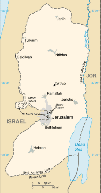
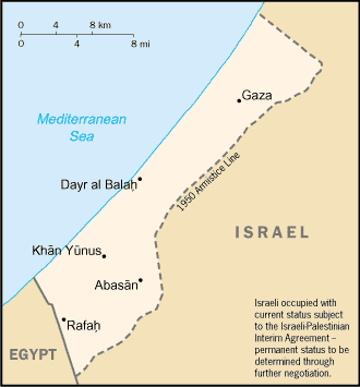
Location:
Area: total: 5,860 sq km land: 5,640 sq km water: 220 sq km Area -
comparative: slightly smaller than Delaware Land boundaries: 404 km border
countries: Israel 307 km, Jordan 97 km.
Climate and Terrain:
Temperate; temperature and precipitation vary with altitude, warm to hot
summers, cool to mild winters. Terrain: mostly rugged dissected upland, some
vegetation in west, but barren in east.
People:
People Population: 2,090,713. Note: in addition, there are
some 176,000 Israeli settlers in the West Bank and about 173,000 in East
Jerusalem.
Ethnic groups: Palestinian Arab and other 83%, Jewish 17%. Religions:
Muslim 75% (predominantly Sunni), Jewish 17%,
Christian and other 8% Languages: Arabic, Hebrew (spoken by Israeli
settlers.
Economy overview:
Real per capita GDP for the West Bank and Gaza Strip
(WBGS) declined by 36.1% between 1992 and 1996 owing to the combined effect of
falling aggregate incomes and rapid population growth. The downturn in economic
activity was largely the result of Israeli closure policies - the imposition of
border closures in response to security incidents in Israel.
Return to Visiting Locations
|