|
Panama
Background:
With US backing, Panama seceded from Colombia in 1903 and promptly signed a
treaty with the US allowing for the construction of a canal and US sovereignty
over a strip of land on either side of the structure (the Panama Canal Zone).
The US Army Corps of Engineers between 1904 and 1914 built the Panama Canal.
Certain portions of the Zone and increasing responsibility over the Canal were
turned over in the intervening years.
|
|
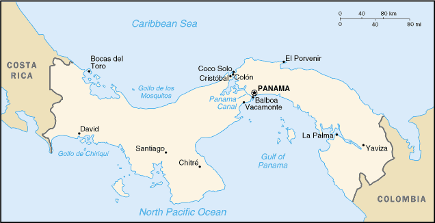
Climate and Terrain:
Climate: Tropical maritime; hot, humid, cloudy; prolonged rainy season (May to
January), short dry season (January to May).
Terrain: Interior mostly steep, rugged mountains and dissected, upland plains;
coastal areas largely plains and rolling hills.
Natural resources: Copper, mahogany forests, shrimp, hydropower.
|
||
|
Economy overview:
Panama's economy is based primarily on a well-developed services sector that
accounts for three-fourths of GDP. Services include the Panama Canal, banking,
the Colon Free Zone, insurance, container ports, flagship registry, and
tourism. A slump in Colon Free Zone and agricultural exports, the global
slowdown, and the withdrawal of US military forces held back economic growth in
2000-01.
GDP - composition by sector: Agriculture: 7%, industry: 17%, services: 76%.
|
||