|
Papua New Guinea
Background:
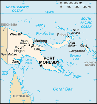
The eastern half of the island of New Guinea - second largest in
the world - was divided between Germany (north) and the UK (south) in 1885. The
latter area was transferred to Australia in 1902, which occupied the northern
portion during World War I and continued to administer the combined areas until
independence in 1975. A nine-year secessionist revolt on the island of
Bougainville ended in 1997, after claiming some 20,000 lives.
Location:
Southeastern Asia, group of islands including the eastern half of the
island of New Guinea between the Coral Sea and the South Pacific Ocean, east of
Indonesia.
Area - comparative: Slightly larger than California.
Coastline: 5,152 km.
Climate and Terrain:
Tropical; northwest monsoon (December to March), southeast monsoon
(May to October); slight seasonal temperature variation.
Mostly mountains with coastal lowlands and rolling foothills.
Elevation extremes: Lowest point: Pacific Ocean 0 m, highest point: Mount
Wilhelm 4,509 m.
Natural resources: Gold, copper, silver, natural gas, timber, oil, fisheries.
Land use: Arable land: 0.1%, forests and woodland: 92.9%, other: 6%.
People:
Population: 5,049,055.
Ethnic groups: Melanesian, Papuan, Negrito, Micronesian, Polynesian.
Religions: Roman Catholic 22%, Lutheran 16%, Presbyterian/Methodist/London
Missionary Society 8%, Anglican 5%, Evangelical Alliance 4%, Seventh-Day
Adventist 1%, other Protestant 10%, indigenous beliefs 34%/
Languages: English spoken by 1%-2%, 715 indigenous languages.
Government:
Capital: The Settlement.
Economy overview:
Papua New Guinea is richly endowed with natural resources,
but exploitation has been hampered by the rugged terrain and the high cost of
developing infrastructure. Agriculture provides a subsistence livelihood for
85% of the population. Mineral deposits, including oil, copper, and gold,
account for 72% of export earnings.
Agriculture - products: Coffee, cocoa, coconuts, palm kernels, tea, rubber,
sweet potatoes, fruit, vegetables; poultry, pork.
Statistics:
Telephones - main lines in use: 47,000.
Telephones - mobile cellular: 3,053.
Radio broadcast stations: AM 8, FM 19, shortwave 28.
Radios: 410,000.
Television broadcast stations: 3.
Televisions: 42,000.
Internet country code: .pg
Internet users: 2,000.
Railways: 0 km.
Highways: Total: 19,600 km, paved: 686 km, unpaved: 18,914 km.
Waterways: 10,940 km.
Airports - with paved runways: 20, with unpaved runways: 472.
Return to Visiting Locations
|