|
Peru
Background:
Ancient Peru was the seat of several prominent Andean civilizations, most
notably that of the Incas whose empire was captured by the Spanish
conquistadores in 1533. Peruvian independence was declared in 1821, and
remaining Spanish forces defeated in 1824. After a dozen years of military
rule, Peru returned to democratic leadership in 1980, but experienced economic
problems and the growth of a violent insurgency. President Alberto Fujimori's
election in 1990 ushered in a decade that saw a dramatic turnaround in the
economy and significant progress in curtailing guerrilla activity.
A caretaker government oversaw new elections in the
spring of 2001, which ushered in Alejandro Toledo as the new head of government.
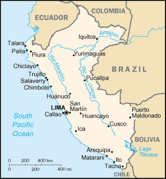
Location:
Western South America, bordering the South Pacific Ocean, between Chile and
Ecuador.
Area: Total: 1,285,220 sq km, water: 5,220 sq km. land: 1.28 million sq km.
Area - comparative: Slightly smaller than Alaska.
Land boundaries: Total: 5,536 km, border countries: Bolivia 900 km, Brazil
1,560 km, Chile 160 km, Colombia 1,496 km (est.), Ecuador 1,420 km.
Coastline: 2,414 km.
Climate and Terrain:
Climate: Varies from tropical in east to dry desert in west; temperate to
frigid in Andes.
Terrain: Western coastal plain, high and rugged Andes in center (sierra),
eastern lowland jungle of Amazon Basin.
Natural resources: Copper, silver, gold, petroleum, timber, fish, iron ore,
coal, phosphate, potash, hydropower, natural gas.
People:
Population: 27,949,639.
Ethnic groups: Amerindian 45%, mestizo (mixed Amerindian and white) 37%, white
15%, black, Japanese, Chinese, and other 3%.
Religions: Roman Catholic 90%.
Languages: Spanish (official), Quechua (official), Aymara.
Government:
Government type: Constitutional republic.
Capital: Lima.
Independence: 28 July 1821 (from Spain).
Economy overview:
Thanks to strong foreign investment and the cooperation between the government
and the IMF and World Bank, growth was strong in 1994-97 and inflation was
brought under control. In 1998, El Nino's impact on agriculture, the financial
crisis in Asia, and instability in Brazilian markets undercut growth. And 1999
was another lean year for Peru, with the aftermath of El Nino and the Asian
financial crisis working its way through the economy. Political instability
resulting from the presidential election and FUJIMORI's subsequent departure
from office limited growth in 2000.
GDP - composition by sector: Agriculture: 10%, industry: 35%, services: 55%.
Statistics:
Telephones - main lines in use: 1.509 million.
Telephones - mobile cellular: 504,995.
Radio broadcast stations: AM 472, FM 198, shortwave 189.
Radios: 6.65 million.
Television broadcast stations: 13 (plus 112 repeaters).
Televisions: 3.06 million.
Internet users: 400,000.
Railways: Total: 2,102 km,
Highways: total: 72,900 km, paved: 8,700 km, unpaved: 64,200 km.
Airports: 239, with paved runways: 47, with unpaved runways: 192.
Return to Visiting Locations
|