|
Portugal
Background:
Following its heyday as a world power during the 15th and 16th centuries,
Portugal lost much of its wealth and status with the destruction of Lisbon in a
1755 earthquake, occupation during the Napoleonic Wars, and the independence in
1822 of Brazil as a colony. A 1910 revolution deposed the monarchy; for most of
the next six decades repressive governments ran the country. In 1974, a
left-wing military coup installed broad democratic reforms. The following year
Portugal granted independence to all of its African colonies. Portugal entered
the EC (now the EU)in 1985.
Location:
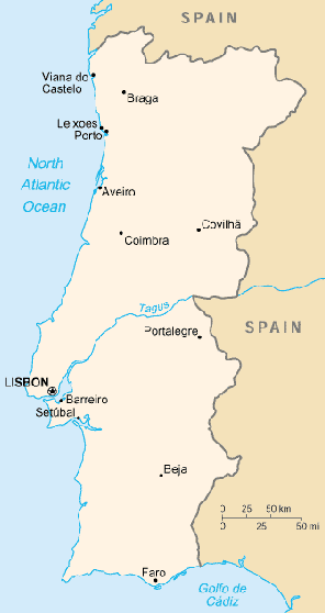
Southwestern Europe, bordering the North Atlantic Ocean, west of Spain
Area: Total: 92,391 sq km, land: 91,951 sq km, note: includes Azores and
Madeira Islands, water: 440 sq km.
Area - comparative: Slightly smaller than Indiana.
Land boundaries: Total: 1,214 km, border countries: Spain 1,214 km.
Coastline: 1,793 km.
Climate and Terrain:
Climate: Maritime temperate; cool and rainy in north, warmer and drier in south.
Terrain: Mountainous north of the Tagus River, rolling plains in south.
People:
Population: 10,084,245.
Ethnic groups: Homogeneous Mediterranean stock; citizens of black African
descent who immigrated to mainland during decolonization number less than
100,000; since 1990 East Europeans have entered Portugal.
Religions: Roman Catholic 94%, Protestant.
Languages: Portuguese.
Government:
Government type: Parliamentary democracy.
Capital: Lisbon.
Independence: 1143 (independent republic proclaimed 5 October 1910).
Economy overview:
Portugal has become a diversified and increasingly service-based economy since
joining the European Community in 1986. Over the past decade, successive
governments have privatized many state-controlled firms and liberalized key
areas of the economy, including the financial and telecommunications sectors.
The country qualified for the European Monetary Union (EMU) in 1998 and began
circulating its new currency, the euro, on 1 January 2002 along with 11 other
EU member economies. Economic growth has been above the EU average for much of
the past decade, but GDP per capita stands at just 75% of that of the leading
EU economies.
GDP - composition by sector: Agriculture: 3.8%, industry: 30.5%, services:
65.7%.
Statistics:
Telephones - main lines in use: 5.3 million.
Telephones - mobile cellular: 3,074,194.
Radio broadcast stations: AM 47, FM 172 (many are repeaters), shortwave 2.
Radios: 3.02 million.
Television broadcast stations: 62 (plus 166 repeaters).
Televisions: 3.31 million.
Internet users: 2 million.
Railways: Total: 2,850 km.
Highways: Total: 68,732 km, paved: 59,110 km, unpaved: 9,622 km.
Airports: 67, with paved runways: 40, with unpaved runways: 27.
Return to Visiting Locations
|