|
Senegal
Background:
Independent from France in 1960, Senegal joined with The Gambia to form the
nominal confederation of Senegambia in 1982. However, the envisaged integration
of the two countries was never carried out, and the union was dissolved in
1989. Despite peace talks, a southern separatist group sporadically has clashed
with government forces since 1982. Senegal has a long history of participating
in international peacekeeping.
Location:
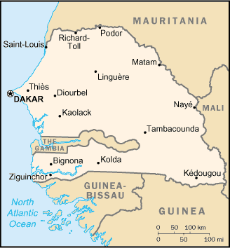
Location: Western Africa, bordering the North Atlantic Ocean, between
Guinea-Bissau and Mauritania.
Area: Total: 196,190 sq km, land: 192,000 sq km, water: 4,190 sq km.
Area - comparative: Slightly smaller than South Dakota
Land boundaries: Total: 2,640 km, border countries: The Gambia 740 km, Guinea
330 km, Guinea-Bissau 338 km, Mali 419 km, Mauritania 813 km.
Coastline: 531 km.
Climate and Terrain:
Climate: Tropical; hot, humid; rainy season (May to November) has strong
southeast winds; dry season (December to April) dominated by hot, dry,
harmattan wind.
Terrain: Generally low, rolling, plains rising to foothills in southeast.
Natural resources: Fish, phosphates, iron ore.
People:
Population: 10,580,307.
Ethnic groups: Wolof 43.3%, Pular 23.8%, Serer 14.7%, Jola 3.7%, Mandinka 3%,
Soninke 1.1%, European and Lebanese 1%, other 9.4%.
Religions: Muslim 94%, indigenous beliefs 1%, Christian 5% (mostly Roman
Catholic).
Languages: French (official), Wolof, Pulaar, Jola, Mandinka.
Government:
Government type: Republic under multiparty democratic rule.
Capital: Dakar.
Independence: 4 April 1960 (from France); complete independence was achieved
upon dissolution of federation with Mali on 20 August 1960.
Economy overview:
In January 1994, Senegal undertook a bold and ambitious economic reform program
with the support of the international donor community. This reform began with a
50% devaluation of Senegal's currency, the CFA franc, which was linked at a
fixed rate to the French franc. Government price controls and subsidies have
been steadily dismantled. After seeing its economy contract by 2.1% in 1993,
Senegal made an important turnaround, thanks to the reform program, with real
growth in GDP averaging 5% annually during 1995-2002. Annual inflation had been
pushed down to less than 1%, but rose to an estimated 3.3% in 2001 and 3.0% in
2002. Senegal is
working toward greater regional integration with a unified external tariff.
Senegal also realized full Internet connectivity in 1996, creating a mini-boom
in information technology-based services.
Statistics:
Telephones - main lines in use: 234,916 .
Telephones - mobile cellular: 373,965.
Radio broadcast stations: AM 8, FM 20, shortwave 1.
Radios: 1.24 million.
Television broadcast stations: 1.
Televisions: 361,000.
Internet users: 100,000.
Railways: Total: 906 km.
Highways: Total: 14,576 km, paved: 4,271, unpaved: 10,305 km.
Airports - with paved runways: 9, with unpaved runways: 11
Return to Visiting Locations
|