|
Sudan
Background:
Military regimes favoring Islamic-oriented governments have dominated national
politics since independence from the UK in 1956. Sudan has been embroiled in a
civil war for all but 10 years of this period (1972-82). The wars are rooted in
northern economic, political, and social domination of non-Muslim, non-Arab
southern Sudanese. Since 1983, the war and war- and famine-related effects have
led to more than 2 million deaths and over 4 million people displaced. The
ruling regime is a mixture of military elite and an Islamist party that came to
power in a 1989 coup. The referendum was held in January 2011 and indicated
overwhelming support for independence. South Sudan became independent on 9 July
2011.
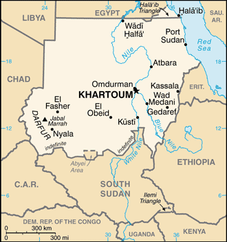
Location:
Location: Northern Africa, bordering the Red Sea, between Egypt and Eritrea.
Area: Total: 1,861,484 sq km.
Area - comparative: Slightly more than one-fifth the size of the US.
Land boundaries: Total: 7,687 km, border countries: Central African Republic
175 km, Chad 1,360 km, Egypt 1,275 km, Eritrea 605 km, Ethiopia 769 km, Libya
383 km, South Sudan 2,184 km.
Coastline: 853 km.
Climate and Terrain:
Climate: Hot and dry; arid desert; rainy season varies by region (April to
November).
Terrain: Generally flat, featureless plain; desert dominates the north.
Natural resources: Petroleum; small reserves of iron ore, copper, chromium ore,
zinc, tungsten, mica, silver, gold, hydropower.
People:
Population: 34,206,710.
Ethnic groups: Black 52%, Arab 39%, Beja 6%, foreigners 2%, other 1%.
Religions: Sunni Muslim, small Christian minority.
Languages: Arabic (official), English (official), Nubian, Ta Bedawie, Fur.
note: program of "Arabization" in process.
Government:
Government type: Federal republic ruled by the National Congress Party the
(NCP), which came to power by military coup in 1989.
Capital: Khartoum.
Independence: 1 January 1956 (from Egypt and UK).
Economy overview:
Sudan is an extremely poor country that has had to deal with social conflict,
civil war, and the July 2011 secession of South Sudan - the region of the
country that had been responsible for about three-fourths of the former Sudan's
total oil production. The oil sector had driven much of Sudan's GDP growth
since it began exporting oil in 1999. For nearly a decade, the economy boomed
on the back of increases in oil production, high oil prices, and significant
inflows of foreign direct investment. Following South Sudan's secession, Sudan
has struggled to maintain economic stability, because oil earnings now provide
a far lower share of the country's need for hard currency and for budget
revenues. Sudan is attempting to generate new sources of revenues, such as from
gold mining, while carrying out an austerity program to reduce
expenditures.
Statistics:
Telephones - main lines in use: 374,700.
Broadcast media: The Sudanese Government directly controls TV and radio,
requiring that both media reflect government policies; TV has a permanent
military censor; a private radio station is in operation. Internet users: 4.2
million.
Railways: Total: 5,978 km .
Highways: Total: 11,900 km, paved: 4,320 km, unpaved: 7,580 km.
Airports - with paved runways: 17, with unpaved runways: 99.
Return to Visiting Locations
|