|
Tajikistan
Background:
Tajikistan has experienced three changes in government and a five-year civil
war since it gained independence in 1991 from the USSR. A peace agreement among
rival factions was signed in 1997, and implemented in 2000. The central
government's less than total control over some areas of the country has forced
it to compromise and forge alliances among factions. Attention by the
international community in the wake of the war in Afghanistan has brought
increased economic development assistance, which could create jobs and increase
stability in the long term. Tajikistan is in the early stages of seeking World
Trade Organization membership and has joined NATO's Partnership for Peace.
|
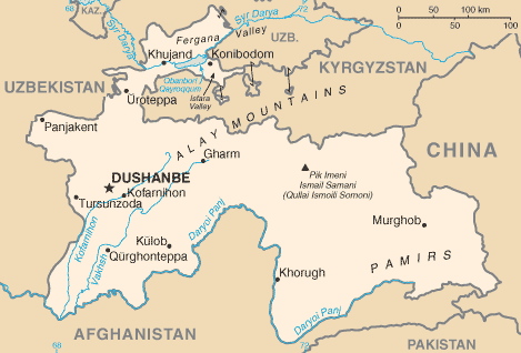
Climate and Terrain:
Climate: Mid-latitude continental, hot summers, mild winters; semiarid to polar
in Pamir Mountains.
Terrain: Pamir and Alay Mountains dominate landscape; western Fergana Valley in
north, Kofarnihon and Vakhsh Valleys in southwest.
Natural resources: Hydropower, some petroleum, uranium, mercury, brown coal,
lead, zinc, antimony, tungsten, silver, gold.
|
|
|
Economy overview:
Tajikistan has the lowest per capita GDP among the 15 former Soviet republics.
Only 8% to 10% of the land area is arable. Cotton is the most important crop.
Mineral resources, varied but limited in amount, include silver, gold, uranium,
and tungsten. Industry consists only of a large aluminum plant, hydropower
facilities, and small obsolete factories mostly in light industry and food
processing. The civil war (1992-97) severely damaged the already weak economic
infrastructure and caused a sharp decline in industrial and agricultural
production.
|
|