|
Tanzania
Background:
Shortly after independence, Tanganyika and Zanzibar merged to form
the nation of Tanzania in 1964. One-party rule came to an end in 1995 with the
first democratic elections held in the country since the 1970s.
Location:
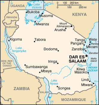
Eastern Africa, bordering the Indian Ocean, between Kenya and
Mozambique.
Area: Total: 945,087 sq km land: 886,037 sq km water: 59,050 sq km
note: includes the islands of Mafia, Pemba, and Zanzibar.
Area - comparative: Slightly larger than twice the size of California.
Land boundaries: Total: 3,402 km border countries: Burundi 451 km, Kenya
769 km, Malawi 475 km, Mozambique 756 km, Rwanda 217 km, Uganda 396 km, Zambia
338 km.
Coastline: 1,424 km.
Climate and Terrain:
Climate: Varies from tropical along coast to temperate in highlands.
Terrain: Plains along coast; central plateau; highlands in north, south .
Natural resources: Hydropower, tin, phosphates, iron ore, coal, diamonds,
gemstones, gold, natural gas, nickel.
Land use: Arable land: 3% permanent crops: 1% permanent pastures: 40%
forests and woodland: 38% other: 18%.
People:
Population: 36,232,074.
Ethnic groups: mainland - native African 99% (of which 95% are Bantu consisting
of more than 130 tribes.
Religions: mainland - Christian 45%, Muslim 35%, indigenous beliefs 20%;
Zanzibar - more than 99% Muslim.
Languages: Kiswahili or Swahili (official), Kiunguju (name for Swahili in
Zanzibar), English (official, primary language of commerce, administration, and
higher education), Arabic.
Government:
Government type: Republic.
Capital: Dar es Salaam.
Economy overview:
Tanzania is one of the poorest countries in the world. The
economy is heavily dependent on agriculture, which accounts for half of GDP,
provides 85% of exports, and employs 80% of the work force.
GDP - composition by sector: Agriculture: 49% industry: 17% services: 34% .
Labor force - by occupation: Agriculture 80%, industry and commerce 20%.
Agriculture - products: Coffee, sisal, tea, cotton, pyrethrum (insecticide made
from chrysanthemums), cashew nuts, tobacco, cloves (Zanzibar), corn, wheat,
cassava (tapioca), bananas, fruits, vegetables; cattle, sheep, goats.
Statistics:
Telephones - main lines in use: 127,000.
Telephones - mobile cellular: 30,000.
Radio broadcast stations: AM 12, FM 11.
Radios: 8.8 million.
Television broadcast stations: 3.)
Televisions: 103,000.
Internet users: 25,000.
Railways: Total: 3,569 km.
Highways: Total: 88,200 km paved: 3,704 km unpaved: 84,496 km.
Airports - with paved runways: 11, with unpaved runways: 115.
Return to Visiting Locations
|

