|
Tokelau
Background:
Originally settled by Polynesian emigrants from surrounding island groups, the
Tokelau Islands were made a British protectorate in 1889. They were transferred
to New Zealand administration in 1925.
Location:
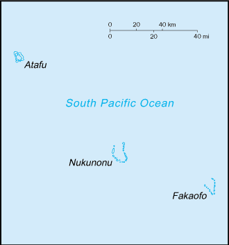
Location: Oceania, group of three atolls in the South Pacific Ocean, about
one-half of the way from Hawaii to New Zealand.
Area: total: 10 sq km.
Area - comparative: About 17 times the size of The Mall in Washington, DC.
Coastline: 101 km.
Climate and Terrain:
Climate: Tropical; moderated by trade winds (April to November).
Terrain: Low-lying coral atolls enclosing large lagoons.
Geography - note: Consists of three atolls, each with a lagoon surrounded by a
number of reef-bound islets of varying length and rising to over three meters
above sea level.
People:
Population: 1,418.
Ethnic groups: Polynesian.
Religions: Congregational Christian Church 70%, Roman Catholic 28%, other 2%.
Languages: Tokelauan (a Polynesian language), English. We had 3 request from
here in August 2006.
Government:
Dependency status: Self-administering territory of New Zealand; note -
Tokelauans are drafting a constitution and developing institutions and patterns
of self-government as Tokelau moves toward free association with New Zealand.
Capital: None; each atoll has its own administrative center.
Economy overview:
Tokelau's small size (three villages), isolation, and lack of resources greatly
restrain economic development and confine agriculture to the subsistence level.
The people rely heavily on aid from New Zealand - about $4 million annually -
to maintain public services, with annual aid being substantially greater than
GDP. The principal sources of revenue come from sales of copra, postage stamps,
souvenir coins, and handicrafts. Money is also remitted to families from
relatives in New Zealand.
Statistics:
Radios: 1,000.
Railways: 0 km.
Airports: None; lagoon landings are possible by amphibious aircraft.
Return to Visiting Locations
|