|
Trinidad and Tabago
Background:
The islands came under British control in the 19th century;
independence was granted in 1962. The country is one of the most prosperous in
the Caribbean thanks largely to petroleum and natural gas production and
processing. Tourism, mostly in Tobago, is targeted for expansion and is
growing.
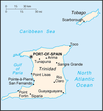
Location:
Caribbean, islands between the Caribbean Sea and the North Atlantic
Ocean, northeast of Venezuela.
Area: Total: 5,128 sq km.
Area - comparative: Slightly smaller than Delaware
Coastline: 362 km
Climate and Terrain:
Tropical; rainy season (June to December).
Mostly plains with some hills and low mountains.
Elevation extremes: Lowest point: Caribbean Sea 0 m, highest point: El Cerro
del Aripo 940 m.
Natural resources: petroleum, natural gas, asphalt.
Land use: Arable land: 15% forests and woodland: 46%.
People:
Population: 1,169,682.
Ethnic groups: black 39.5%, East Indian (a local term - primarily immigrants
from northern India) 40.3%, mixed 18.4%, white 0.6%, Chinese and other 1.2%.
Religions: Roman Catholic 29.4%, Hindu 23.8%, Anglican 10.9%, Muslim 5.8%,
Presbyterian 3.4%, other 26.7%.
Languages: English (official), Hindi, French, Spanish, Chinese.
Government:
Capital: Port-of-Spain. Independence: 31 August 1962 (from UK).
Economy overview:
Trinidad and Tobago has earned a reputation as an excellent
investment site for international businesses. Successful economic reforms were
implemented in 1995, and foreign investment and trade are flourishing.
Persistently high unemployment remains one of the chief challenges of the
government. The petrochemical sector has spurred growth in other related
sectors, reinforcing the government's commitment to economic diversification.
Tourism is growing, especially in the pleasure boat sector. New investment and
construction also will continue to drive the economy.
Labor force - by occupation: Construction and utilities 12.4%, manufacturing,
mining, and quarrying 14%, agriculture 9.5%, services 64.1%.
Agriculture - products: cocoa, sugarcane, rice, citrus, coffee, vegetables;
poultry.
Statistics:
Telephones - main lines in use: 243,000.
Telephones - mobile cellular: 17,411.
Radio broadcast stations: AM 2, FM 12.
Radios: 680,000 (1997)
Television broadcast stations: 4.
Televisions: 425,000.
Internet users: 30,000.
Highways: Total: paved: 4,252 km, unpaved: 4,068 km.
Airports: 6.
Return to Visiting Locations
|