|
Turks and Caicos Islands
Background:
The islands were part of the UK's Jamaican colony until 1962, when they assumed
the status of a separate crown colony upon Jamaica's independence. The governor
of The Bahamas oversaw affairs from 1965 to 1973. With Bahamian independence,
the islands received a separate governor in 1973. Although independence was
agreed upon for 1982, the policy was reversed and the islands are presently a
British overseas territory.
1990.
Location:
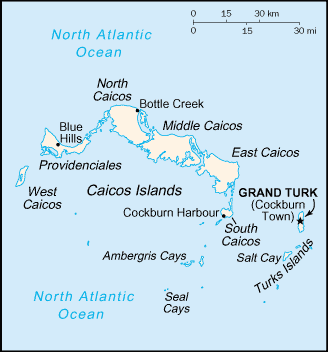
Location: Caribbean, two island groups in the North Atlantic Ocean, southeast
of The Bahamas.
Map references: Central America and the Caribbean.
Area: Total: 430 sq km.
Area - comparative: 2.5 times the size of Washington, DC.
Coastline: 389 km.
Climate and Terrain:
Climate: Tropical; marine; moderated by trade winds; sunny and relatively dry.
Terrain: Low, flat limestone; extensive marshes and mangrove swamps.
Elevation extremes: Lowest point: Caribbean Sea 0 m, highest point: Blue Hills
49 m.
Natural resources: Spiny lobster, conch.
People:
Population: 18,738.
Ethnic groups: Black.
Religions: Baptist 40%, Methodist 16%, Anglican 18%, Church of God 12%, other
14%.
Languages: English (official).
Government:
Overseas territory of the UK.
Capital: Grand Turk (Cockburn Town).
Economy overview:
The Turks and Caicos economy is based on tourism, fishing, and offshore
financial services. Most capital goods and food for domestic consumption are
imported. The US is the leading source of tourists, accounting for more than
half of the 93,000 visitors in 1998. Major sources of government revenue
include fees from offshore financial activities and customs receipts.
Industries: Tourism, offshore financial services.
Statistics:
Telephones - main lines in use: 3,000.
Radio broadcast stations: AM 3, FM 6.
Radios: 8,000.
Railways: 0 km.
Highways: Total: 121 km, paved: 24 km, unpaved: 97 km.
Airports - with paved runways: 5, with unpaved runways: 3.
Return to Visiting Locations
|

