|
Wake Island
Background:
The US annexed Wake Island in 1899 for a cable station. An important air and
naval base was constructed in 1940-41. In December 1941, the island was
captured by the Japanese and held until the end of World War II. In subsequent
years, Wake was developed as a stopover and refueling site for military and
commercial aircraft transiting the Pacific. Since 1974, the US military and
some commercial cargo planes, as well as for emergency landings, have used the
island's airstrip. There are over 700 landings a year on the island.
Location:
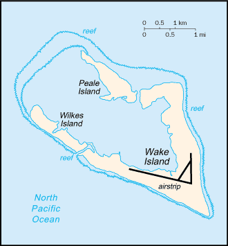
Location: Oceania, atoll in the North Pacific Ocean, about two-thirds of the
way from Hawaii to the Northern Mariana Islands.
Area: Total: 6.5 sq km.
Area - comparative: About 11 times the size of The Mall in Washington, DC.
Coastline: 19.3 km.
Maritime claims: Exclusive economic zone: 200 NM, territorial sea: 12 NM.
Climate and Terrain:
Climate: Tropical.
Terrain: Atoll of three coral islands built up on an underwater volcano;
central lagoon is former crater, islands are part of the rim.
Elevation extremes: Lowest point: Pacific Ocean 0 m, highest point: unnamed
location 6 m.
Natural resources: None.
Land use: Arable land: 0%.
Geography - note: Strategic location in the North Pacific Ocean; emergency
landing location for transpacific flights.
Return to US Minor Outlying Islands
|
|
People:
Population: No indigenous inhabitants. Note: US military personnel have left
the island, but contractor personnel remain; as of October 2001, 200 contractor
personnel were present.
Government:
Dependency status: Unincorporated territory of the US; administered from
Washington, DC, by the Department of the Interior; activities on the island are
managed by the US Air Force.
Claimed by Marshall Islands.
Economy overview:
Economic activity is limited to providing services to contractors located on
the island. All food and manufactured goods must be imported.
Radio broadcast stations: Armed Forces Radio/Television Service (AFRTS) radio
service provided by satellite.
Statistics:
Ports and harbors: None; two offshore anchorages for large ship.
Airports: 1 (2002)
Transportation - note: Formerly an important commercial aviation base, now used
by US military, some commercial cargo planes, and for emergency landings.
|