|
Wallis and Futuna Islands
Background:
Although discovered by the Dutch and the British in the 17th and 18th
centuries, it was the French who declared a protectorate over the islands in
1842. In 1959, the inhabitants of the islands voted to become a French overseas
territory.
Location:
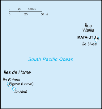
Location: Oceania, islands in the South Pacific Ocean, about two-thirds of the
way from Hawaii to New Zealand.
Area: Total: 274 sq km. note: includes Ile Uvea (Wallis Island), Ile Futuna
(Futuna Island), Ile Alofi, and 20 islets.
Area - comparative: 1.5 times the size of Washington, DC.
Coastline: 129 km.
Climate and Terrain:
Climate: Tropical; hot, rainy season (November to April); cool, dry season (May
to October); rains 2,500-3,000 mm per year (80% humidity); average temperature
26.6 degrees C.
Terrain: Volcanic origin; low hills.
Geography - note: Both island groups have fringing reefs.
People:
Population: 15,734.
Ethnic groups: Polynesian.
Religions: Roman Catholic 99%, other 1%.
Languages: French, Wallisian (indigenous Polynesian language).
Government:
Dependency status: Overseas territory of France.
Capital: Mata-Utu (on Ile Uvea).
Economy overview:
The economy is limited to traditional subsistence agriculture, with about 80%
labor force earnings from agriculture (coconuts and vegetables), livestock
(mostly pigs), and fishing. About 4% of the population is employed in
government. Revenues come from French Government subsidies, licensing of
fishing rights to Japan and South Korea, import taxes, and remittances from
expatriate workers in New Caledonia.
Statistics:
Telephones - main lines in use: 1,125.
Radio broadcast stations: AM 1.
Television broadcast stations: 2.
Railways: 0 km.
Highways: total: 120 km (Ile Uvea 100 km, Ile Futuna 20 km), paved: 16 km (all
on Ile Uvea), unpaved: 104 km (Ile Uvea 84 km, Ile Futuna 20 km).
Airports - with paved runways: 1,
with unpaved runways: 1.
Return to Visiting Locations
|