|
Yugoslavia
Background:
The Kingdom of Serbs, Croats, and Slovenes was formed in 1918; its name was
changed to Yugoslavia in 1929. Various paramilitary bands that fought
themselves as well as the invaders resisted occupation by Nazi Germany in 1941.
The group headed by Marshal Tito took full control upon German expulsion in
1945. Although Communist, his new government successfully steered its own path
between the Warsaw Pact nations and the West for the next four and a half
decades. In the early 1990s, post-Tito Yugoslavia began to unravel along ethnic
lines: Slovenia, Croatia, and The Former Yugoslav Republic of Macedonia all
declared their independence in 1991; Bosnia and Herzegovina in 1992.
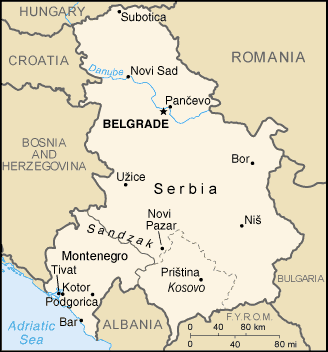
Location:
Southeastern Europe, bordering the Adriatic Sea, between Albania and Bosnia and
Herzegovina.
Area: Total: 102,350 sq km, water: 214 sq km, land: 102,136 sq km.
Area - comparative: Slightly smaller than Kentucky.
Land boundaries: Total: 2,246 km border countries: Albania 287 km, Bosnia and
Herzegovina 527 km, Bulgaria 318 km, Croatia (north) 241 km, Croatia (south) 25
km, Hungary 151 km, The Former Yugoslav Republic of Macedonia 221 km, Romania
476 km.
Coastline: 199 km.
Climate and Terrain:
Climate: In the north, continental climate (cold winters and hot, humid summers
with well distributed rainfall); central portion, continental and Mediterranean
climate; to the south, Adriatic climate along the coast, hot, dry summers and
autumns and relatively cold winters with heavy snowfall inland.
Terrain: Extremely varied; to the north, rich fertile plains; to the east,
limestone ranges and basins.
People:
Population: 10,656,929.
Ethnic groups: Serb 62.6%, Albanian 16.5%, Montenegrin 5%, Hungarian 3.3%,
other 12.6%.
Religions: Orthodox 65%, Muslim 19%, Roman Catholic 4%, Protestant 1%, other
11%.
Languages: Serbian 95%, Albanian 5%.
Government:
Government type: Republic.
Capital: Belgrade.
Independence: 27 April 1992 (Federal Republic of Yugoslavia).
Economy overview:
Milosevic-era mismanagement of the economy, an extended period of economic
sanctions, and the damage to Yugoslavia's infrastructure and industry during
the war in Kosovo has left the economy only half the size it was in 1990. The
smaller republic of Montenegro severed its economy from federal control. The
euro and the Yugoslav dinar are official currencies, and UNMIK collects taxes
and manages the budget.
Statistics:
Telephones - main lines in use: 2.017 million.
Telephones - mobile cellular: 87,000.
Radio broadcast stations: AM 113, FM 194, shortwave 2.
Radios: 3.15 million.
Television broadcast stations: More than 771 (including 86 strong stations and
685 low-power stations.
Televisions: 2.75 million.
Internet users: 400,000.
Railways: total: 4,059 km.
Highways: Total: 48,603 km, paved: 28,822 km, unpaved: 19,781 km.
Airports: 46, with paved runways: 19, with unpaved runways: 27.
Heliports: 2.
Return to Visiting Locations
|
