|
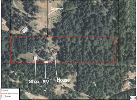
Nolls Oregon Home Satellite View - 98 In the 2009 the Willamette Watershed Council asked us if they could survey our land for a noxious weed "False Brome." We agreed and they found some isolated plants on our property. Later in 2010 they removed the plants with our permission. They left us with an aerial satellite photo of our property. The house, shop and RV building are clearly marked on the photo. A little over half of the property on the right side we have left in the wild. The deer, and many other wildlife enjoy then and the protection it affords them. We enjoy their presence. We own the driveway. It is about 1/3 mile long and connects with Pierland Lane. ⇦ Back to Page 97 On to Page 99 ⇨Hi-Res Pic (104K) Return to Noll Home Scenes - Page 13 |