|
Devil's Punchbowl State Park
1. Map to Devil's Punchbowl Devil's Punchbowl lies just off Hwy 101 in Otter Rock scenic bypass, 8 miles north of Newport at milepost 132. ⇦ Back to Page 13 On to Page 2 ⇨Return to Devil's Punchbowl - Page 1 |
|
|
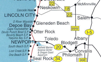
Devil's Punchbowl State Park
1. Map to Devil's Punchbowl Devil's Punchbowl lies just off Hwy 101 in Otter Rock scenic bypass, 8 miles north of Newport at milepost 132. ⇦ Back to Page 13 On to Page 2 ⇨Return to Devil's Punchbowl - Page 1 |