|
Yaquina Bay Park
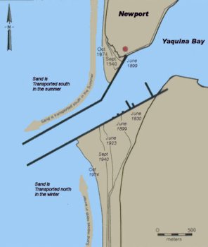
6. Newport Jetty Map The alongshore movement of sand can create shifting sandbars at harbor entrances that pose hazard to navigation. Jetties, like those at the entrance to Yaquina Bay, diffuse the powerful action of waves and current, and by interrupting the movement of sand, they help keep the harbor entrances open for vessel traffic. The longshore current changes direction seasonally due to changes in the prevailing wind, transporting sand northward in winter and southward in summer. You can see the buildup of sand over the years on both the north and south ends of the jetty. ⇦ Back to Page 5 On to Page 7 ⇨Return to Yaquina Bay - Page 1 |