|
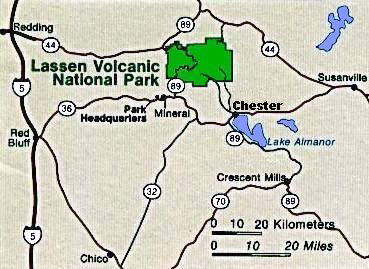
Mount Lassen National Park 1. Park Map Beneath Lassen Volcano's peaceful forests and gem-like lakes lies evidence of a turbulent and fiery past. 600,000 years ago, the collision and warping of continental plates led to violent eruptions and the formation of lofty Mt. Tehama (also called Brokeoff Volcano.) After 200,000 years of volcanic activity, vents and smaller volcanoes on Tehama's flanks (including Lassen Peak) drew magma away from the main cone. Hydrothermal areas ate away at the great mountain's bulk. Beneath the onslaught of Ice Age glaciers, Mt. Tehama crumbled and finally ceased to exist. But the volcanic landscape lived on: in 1914, Lassen Peak awoke. The Peak had its most significant activity in 1915 and minor activity through 1921. Lassen Volcanic became a national park in 1916 because of its significance as an active volcanic landscape. During the years we camped at Lassen we had lived in the San Francisco Bay area at Hayward, California. So we generally came from the south and turned east at Red Bluff, California on California highway 36. Most of the time we camped at the Manzanita Campground. The snow at Lassen Park would be still high as late as July. One July 4th trip we arrived to find snow along the highway still as high as 12-15 feet although the roads had been cleared. ⇦ Back to Page 30 Return to Mt. Lassen -- Page 1 On to Page 2 ⇨ |
| How to get to Lassen Park |